Ramble On

Monday, June 20, 2011

The Container Garden Takes Over

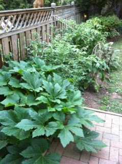
Mary planted a container garden this spring.  Actually it's quite a bit more than that this time, and it has already produced edible food, much better than what I was able to do with my feeble attempt last year.


She has yellow squash, eggplant, tomatoes, and peppers going.  So far, we've harvested squash and eggplant - I grilled some of these over the weekend.  The tomatoes are coming along, probably will have a few ready by the end of this week; I'm not sure about the peppers.

These crops are in the space where our beautiful green wall of leland cypress used to be.  They were casualties of the 2010 winter storms - the snowpocalypse.

Mary visited some neighbors the other day, and they had okra plants to spare...so they gave her six of them.  She planted them at the end of the row, as shown here.  And there's our doggie!


Friday, June 17, 2011

Cape Cod Bright

In addition to the high carbon footprint activities we did while vacationing on Cape Cod, Mary and I had done some research on a few day hikes that we could take in.  Today I'll post about a 2 mile hike through an old cranberry bog in the Truro area of the Cape Cod National Seashore.

I've just done a Google search and found this 17-page interpretive guide to the trail:  http://www.nps.gov/caco/planyourvisit/upload/FinalPametrackcards.pdf.  We happened upon it because some of our Alexandria neighbors had taken in a couple of the day hikes and recommended that we look into them.

Our route took us out into the bog area, but we stopped and enjoyed the view from the high dunes in the area.  The post title refers to the incredible quality of light on the cape - I've heard several hypotheses on why it's so beautiful, including one that said it is so clear because the cape is wind swept from being 30+ miles out into the ocean - this is also why it's so susceptible to winter and spring storms.

The interpretive sign at the start of the trail provides a good overview of the activities, and elsewhere, there is an introduction to how the rolling topography came to be.  The cape itself is left over from glacier activity during the last ice age, and now the sand deposits are more or less maintained by the natural current action of the Atlantic.  Where you find depressions, as in the example here, large ice flows were left to melt there.  Now, when they fill with water, it is often fresh from some filtering action that I don't understand yet.

Mary and I wandered along the trail back in the dunes, which had some stretches that were challenging climbs - not very long, as you're never getting to altitudes higher than 150 feet or so - but because of their steepness and because the trail is loose sand.

We emerged onto the beach about a mile or so after we started.  Here's a view from near the foot of one of the dunes, looking south towards the parking area.  There's a wide upper beach here with a trough that fills in at high tide, which was coming in while we walked along it.

There is a steep beach along the eastern edge, where the waves continuously roll in and crash.

A final note about the topography - this area is called the Pamet River, which is because it provides an outlet from the ocean back to the bay for water that gets inland.  It's not like there's the strong flow like you would find in the Shenandoah, or even Hawksbill Creek - it's more of a standing water, slow current watershed.

But a nor'easter in the winter of 2007 was intense, and broke through the dune one this side.  They say the ocean roared inland past Route 6, and for a time, the northern reaches of the outer cape were an island.  A restoration effort to help the dune rebuild itself is underway, shown here in the last photo.

Thursday, June 16, 2011

Cape Cod Right (*)

* - Technically, we did not see a right whale on this cruise.

For a second adventure during our Cape Cod vacation, I looked into a whale watch cruise.  They are offered out of several harbors on the cape, including Falmouth, Hyannis, and Provincetown.  Although there was a bit of a drive up to Provincetown, Mary and I decided to take our cruise from there on the Dolphin Fleet.  They have a fairly comprehensive website at http://www.whalewatch.com/dolphinfleet/.

After you get on board, the naturalist that accompanies each of the Dophin Fleet cruises begins an orientation tour with safety rules, followed with a list and description of the types of wildlife that could potentially be encountered.  Here are photos of Mary and me just after boarding (taken by a vacationing Brit, we returned the favor for him and his wife, and then saw them strolling around Chatham the next day) and a photo of one of the boats as we left the harbor.

The types of whales that you might see during these cruises include the baleen species right whales, humpback, and finback; also pilot whales and dolphins.  There is a finback photo at the top of this post; we encountered two of them just offshore before we were even clear of the P-town peninsula.  I took the lighthouse photo just after we saw them.

For unusual fish speicies, there is the mola mola or sunfish, and the basking shark, and we saw two each of them, but I did not get photos of them since they were on the other side of the boat. 

Watching the finbacks was quite fascinating - they are the second largest animals on the planet, after blue whales.  They typically have a streamlined, slender build, reaching up to 90 feet in length, and weighing as much at 150,000 pounds.  I took a little time to comprehend this concept, because the whale feeds on plankton - small - microscopic - plants.  Also they can live to be nearly one hundred years old.

After the encounter with the finbacks, we cruised north into protected waters for about a half hour and searched for other animals.  That's where we saw the mola molas, or sunfishes, and the basking sharks. 

Eventually we ended up amongst a large group of dolphins.  There were dozens of them visible on the surface, including this small pod that was at the front of the boat for a while. The estimated count of dolphins in the area was 150.  They did some of the typical performances you might expect from them - high leaps as singles, and some as pairs; then the pilot steered the boat around to make a steep wake and a few of them jetted into the high wave and then exploded out of the surf into the air.  It's easy to see why they hold such a vivid place in the imagination, since they are so gregarious.

So, yeah, this was a very touristy thing to do...but it's not something we would set out to do every time we go up to the cape.  It was a very worthwhile thing to do once...although, if we are ever up during humpback season, it might be worth a second go to encounter them. 

Wednesday, June 15, 2011

Cape Cod Flight

For an adventure during the recent vacation at Cape Cod, I looked into taking a short aerial tour.  We booked an hour long trip out of the Chatham general aviation airport - here are some of the highlights of what we saw.

The first and second images are on the bay side of the cape.  There is a series of sand bars in the first, and the little black dots are an oyster farm.  The second is a salt marsh - we visited another of these in the National Seashore area later in the week.

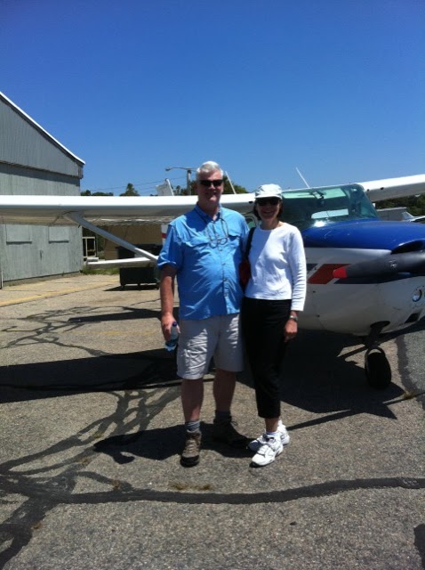
Third:  a picture of Mary and me in front of the little plane before takeoff.  Our flight was level at an altitude of 1,250 feet or so, and we flew at 110 mph.  If you think of the outer cape as being in the shape of Rosie the Riveters bare arm, we flew from the elbow (Chatham) to the fist (Provencetown).  Then we added a little tour over Monomoy island, with a seal colony numbering in the thousands.  And somewhere on the horizon there, in the fourth picture, would be Nantucket Island in Connecticut. 

For the fifth photo, here is the inlet at Wellfleet and the harbor.  Then a shot of the Chatham Bars area, with the wonderfull green water.


The final picture, appropriately, is a shot of our approach on final.  In some of the pictures, you can see the fixed landing gear of the little plane, but in this one, you can see the prop blade as the camera lens appeared to slow it down.  I think you will see the blade in some of the other photos as well.

Here's a link to the tour operator's page:  http://www.chathamairport.com/aerial_tours.php
We took the Captain Douglas special - be sure to check for current pricing before you book!


Tuesday, June 14, 2011

"All Things Cape Cod League"

As our vacation week progressed, I became aware that the Cape Cod Baseball League would have its season opener on Friday, and that the Chatham Anglers, the local team where we were staying, would have their home opener on Saturday night. So after a great visit with my friend John and his daughter Tildy (John and I were stationed in Berlin together, and Tildy is a rising sophomore at Wellesley), Mary and I ventured out into a rainy and cold spring evening on the Cape for the game.

Another friend from Berlin, Brian, is a Cape League enthusiast. Last year, I caught up with him in San Francisco, where he wore a Wareham Gatemen baseball cap around town. By coincidence, that’s who the Chatham team played for the opener. I have a couple of photos of the game here – the teams during the National Anthem, and another with the Anglers up to bat.

This league has a long history, and since the Cape has long been a summer destination, league play has been romanticized into the popular culture there. I’ll admit I was a bit caught up in it, despite the jacket I had to wear to the game, and the fact that other fans in the stands with us were in parkas and gloves. It did make me think of our own Valley Baseball League and the Luray Wranglers, as well.

It turns out that the Cape Cod and Valley leagues share a few characteristics. Both are part of the National Alliance of Summer Baseball, which features collegiate players with NCAA authorization, and some sponsorship from the major leagues. Both are “wood bat leagues.” And both are represented by many current and past pro players, including hall of famers.

In keeping with the summer getaway theme, according to Wikipedia, the Cape Cod league has been the subject of a couple of movies over the last 20 years or so, and there are a couple of books on the topic.  All great...but then, the Valley  league has one of the best blogs going for it: All Things Valley League (link:  http://allthingsvalleyleague.typepad.com/)!


We had a nice time, and the little stadium in Chatham is a charm. But the weather was a bit much and we headed home after three innings, with the Gatemen up 4-0 already.

I’m looking forward to catching my first Wranglers game soon, though - no parkas and gloves, and afterwards, a nice cookout with some Page County sweet corn!

Monday, June 13, 2011

Just Back

Mary and I are just back from vacation in Cape Cod, so I have a few items to post after a week away.  We once again stayed at the little house in Chatham, she tacked the vacation week onto the end of her college reunion.  It made for a great week.

I've written about the town and this house before - we stayed there last September as well, but this was the first time in a very long time we took a full week off on an official vacation.  I think this fact had a lot to do with the old pups Gracie and Sofie, who we preferred not to leave with a sitter or to kennel in their old age, once they got past 12 or so.  In thinking about it this morning, we last took a week off together to head down to the Outer Banks in August 2007 - but there were a lot of things about that trip that probably led to us not doing a real getaway again until just now.

But enough of that rambling.  We went to the wonderful little town of Chatham, and we strung together some adventures and sightseeing, mixed in with visits to old friends and relatives.  So that'll be the ntaure of some of the posts.  First, however, I wanted to write about backyard nature - drawing some inspiration from Richard Louv's "The Nature Principle" - a book I wrote about a couple of weeks ago and read while we were away.

My observations focus on the little shed shown here, which actually belonged to the house next door.  It was literally close enough for me to reach out and touch it from the deck where I drank my coffee every morning (and spent the afternoons reading in the sun), so I had ample time to watch the goings on.

This was taken to show the carpenter bee damage.
The first morning activities were the robins and jays who were out and about at first light.  They quickly grew accustomed to me and soon were ignoring me - until later in the week.  After sunlight began to strike the side of the shed, a big old male carpenter bee, would show up and hover near the shed, his loud buzzing interrupted only by the appearance of female bees, birds, or other potential mates that invaded his space.  (BTW, I noticed a lot of traffic on the blog from searches on carpenter bees and their damage - those page views are referred to old posts I had...this photo of bee damage provides another update).

Late in the morning, and also in the cool of the evening, a couple of young bunnies would hop out from under the shed.  These guys were only 6 inches long or so, clearly only a couple of months old, but already weened and fending for themselves.  They'd hop out into the little side yard there and graze.  In the evening, as things cooled off, they'd play together or by themselves - I saw the smaller one do a series of half turns in place, and vertical leaps over there between blades of grass.

This reminded me of a passage in the Louv book, which I will summarize here - essentially, this is the introduction to the book.  Louv writes:
  • The more high-tech our lives become, the more nature we need to achieve natural balance.
  • The mind/body/nature connection, also called vitamin N (for nature), will enhance physical and mental health.
  • Utilizing both technology and nature experience will increase our intelligence, creative thinking, and productivity, giving birth to the hybrid mind.
  • Human/nature social capital will enrich and redefine community to include all living things.
  • In the new purposeful place, natural history will be as important as human history to regional and personal identity.
  • Through biophilic design, our homes, workplaces, neighborhoods, and town will not only conserve watts, but also produce human energy.
  • In relationship with nature, the high-performance human will conserve and create natural habitat - and economic potential - where we live, learn, work, and play.
In a sense, sitting there watching the birds, bees, and bunnies, I had a sort of vacation laboratory to think about some of these concepts.  This comtemplative time brought home the importance of some of the connections I am fortunate to have out in Page County near the Hawksbill Cabin.  And as much as anything else, that time gave me a sense of urgency for completing the 75@75 project, which I will do this year.

But back to Cape Cod - an altogether different environment for our vacation, with both natural features to enjoy and not too distant from a small town and urban setting, which was also an import for the getaway.  More to follow for the balance of the week.

Here is an Amazon link to Louv's book:

Friday, June 3, 2011

Three Ways to Cross - 3

Finally, here's the video Chris took of me at an earlier, tamer crossing.  Despite the taunting, I emerged dry and saucy.

Three Ways to Cross - 2

Here's Tom's crossing, after watching Chris navigate the high road.  Note:  waterproof boots!


Three Ways to Cross - 1

On the Piney Branch-Piney Ridge trail last weekend, there were four stream crossings.  In each of the guides I checked, there were warnings for the fourth one - the water would be deep, and even dangerous if the current was strong.  This made for some fun, as our group has a little informal pool going for who's going to fall during one of these. 

Now, Tom was the last to fall, but we can't really count that - it was during the ill-fated attempt at near zero temperatures last winter, and we had returned to our cars when he slipped and fell into the shallow but icy water. 

So we had some fun at these stream crossings.  This three part post includes the sequence of Chris and Tom making their way across.  Then at the end, for the first time ever, I'm embedding iPhone footage that Chris had taken of me at the very much tamer first crossing of Piney Branch.  There's some taunting at the beginning, and then, a punchline at the end.

Chris's Crossing:


Thursday, June 2, 2011

Piney Branch - Piney Ridge Trail: a 75@75 Hike (part 2)

The point of these 75@75 hikes is to get into the history of Shenandoah National Park a little more deeply than I have in the past. The hikes all have their physical challenges, since they have been chosen because of their moderate length or elevation change. A second reason for choosing them was the connection to what was here before the Park, since humans have occupied the Blue Ridge from time to time over the last 12,000 years or more, and exploring and settling the Ridge began in earnest during the colonial era.


One of the “traces” that is evident on the Piney Branch-Piney Ridge trail is the Dwyer cemetery, which is one of two cemeteries that are formally mentioned on NPS trail guides and in the Heatwole book.

In the case of the Dwyer cemetery – its current state is best described as returning to nature, since no family members actively maintain it – there is no trace of the old wire fence, and the visible markers remaining are newer, formal markers. The Heatwole guide includes a notation about this family; there were seven families of Dwyers that were displaced from the Park when it was formed, and 850 acres of their land was assimilated into the growing Park.

We met a scout troop leader trailside at the little spur that leads back to the cemetery and had a good chat (he confirmed for Tom, still skeptical at that point, that we had gone the wrong direction on the hike – “but the hardest part is behind you now”). He pointed us to a newer, more formal headstone that had a CSA badge mounted near it; this was from the most recent burial, in 1927. Heatwole also notes that a Mary G. Dwyer is buried here, having died in 1867 at the age of 75.

As we returned to continue up the gently climbing Piney Ridge trail, I thought about some of the trees we were seeing here. I understand that this part of the trail goes through an old goat pasture, and that the trees growing in now are second growth, young hardwoods. There are still some magnificent pines on the ridge and black locust trees, species that are called pioneers and first growth forests as the area is taken back by the woods.

Most likely, none of those specimens are older than the Park, but down on the Piney Branch trail and on the cut-off trail I had seen quite a few tulip poplars, which is also known as the tulip-tree. These trees are magnificent cousins to the magnolias, and can be found in most of the branch, river and creek valleys and ravines at the park. They are an ancient tree, and when you see the little flower, the magnolia is not the first relationship that comes to mind, although the tulip does, but once you see the fruit later in the year and after research, the relationship is clear.

One other plant to note in this traces theme is the thriving tea rose I saw trailside, which is a reminder that this area was well populated, like much of the northern district of the Park. There are a couple of old home sites that can be explored, with many decorative and food plants gone feral still remaining. Heatwole notes a grape vine that is three inches in diameter down there…but these areas are in the vicinity of the steep climb, and we were too focused on our misery at that moment.

Early in the hike we’d passed the utility cut that I have a picture of here. Our thoughts considered the descent, and then the ascent, that was shown in this cut. All totaled, we were looking at maybe 200 feet of elevation change – one seventh of the total climb we were in for – but on balance, this third installment of the 75@75 hikes was very rewarding.


Here are some of the reference books I used for this post:


Wednesday, June 1, 2011

Piney Branch - Piney Ridge Trail: a 75@75 Hike (part 1)


For the third hike in the 75@75 project, we chose the Piney Branch-Piney Ridge trail, which is described in the Heatwole guide as 8.3 miles. I’ll split this review into two parts.  For a complete list of planned hikes, see the list at the bottom of this post. 

For technical information, the hike includes an estimated total climb of 1,725 feet, again, according to Heatwole; and the guide provides an estimated time of about 7 and a half hours. By my measurement, I calculated 1,410 feet of absolute elevation change, from approximately the highest point on the trail to the lowest. We completed the hike in about 6 and a half hours, with a half hour lunch break, and a couple of other stops along the way at a stream crossing and at the Dwyer cemetery along the route.

Besides the notation that this is a strenuous trail, Heatwole advises a counter-clockwise loop; also there is the information we had that the four stream crossings could be difficult (or dangerous!) during high water (we didn’t experience that, luckily). But I missed all of that, and I led the group clockwise. And none of my erstwhile hiking partners remembered this either, until we were well underway, and we started encountering people coming towards us on the Piney Branch portion of the hike, that’s when the friendly grumbling began.

Only when we arrived at the Piney Ridge trail at the end did I realize we’d done it in reverse. The relaxed and steady climb through the old goat pasture was a sharp relief from the steep climb – 700 feet in a mile – that we had pulled coming out of the stream bed.  Complicating the matter was the 95 degree heat.  I drank all 2.5 liters of water I carried on this hike.

I included this route on the 75@75 list because of the moderate distance and the (underestimated) climb, but also because it featured several objectives, such as the cemetery, and four stream crossings. But the trail also includes views of two waterfalls, somewhat obscured now that the trees are leafed out, but still visible and definitely audible from the trail.

Heatwole lists 16 waterfalls in his book, with the shortest one noted as 28 feet tall. These two are left off the list, although Heatwole estimated that the taller of these two was unmeasured but around 25 feet. Some recent rains had them running strong, but they were obscured by leaves so I couldn’t get a good photo. It was too strenuous to get down to them for close up, but we agreed that they were dramatic and beautiful.

The trailhead for this hike is near an old CCC camp called Piney River. One of the old lodges still stands, and there are a few other buildings nearby (including residences for NPS employees). Then a short way down the AT here, there is PATC’s Range View Cabin, built in 1933 by PATC, but given to the Park at its establishment and now managed as a concession by PATC.

For photos today, I have a view of one of the cascades along Piney Branch – as you can imagine, with the elevation changes on this trail, they are plentiful. Also, a shot of a serious blowdown we encountered – this one completely blocking the trail so that we had to bushwhack around it (to the uphill side, of course). And finally, an area of the Piney Ridge trail where the chestnuts fell so long ago, and have been cut through to allow passage.

This kind of an area is one of the “ghost forests” you find in Shenandoah National Park, areas where significant tree stands have fallen victim over time to development and other impacts, such as the emerald ash borer problem we are seeing just now. It’s a phenomenon I need to look into more, but there were so many fallen chestnuts through here, all in various stages of decay. They last a long time on the ground, but made a strangely beautiful passage.

A partial list of the hikes on the 75@75 project is here:  http://hawksbillcabin.blogspot.com/2011/05/about-7575-project.html