Ramble On

Showing posts with label Shenandoah National Park. Show all posts

Thursday, September 22, 2016

Revisiting SNP's Black Rock

Since I first discovered the Black Rock Summit hike in 2009, it has been one of my favorites in Shenandoah National Park.  At about one mile round trip and less than 200 feet of altitude gain, it's one of the easiest hikes I go on - and I've been back there five or six times.  The experience of this summit seems like such a great reward for such little effort expended.

I've written about the hike a number of times for this blog as well:


The NPS is observing its centennial this year, and it appears that they have made some enhancements to this hike at the trailhead.  There's an interpretive sign about the AT there now, and there is a little activity guide for kids, describing what they will see on the little hike.


The sign at the trailhead was also updated.  It now includes a substantial description of the geology of the place:


"The exposed rocks of Blackrock formed the seabed of the Iapetus Ocean, an ancient body of water that predates the Appalachian Mountains.  The geological forces that created the mountains changed the seabed into solid quartzite rock. ... Blackrock is still changing.  Weathering has caused what was once a cliff to crumble into a talus slope, a river of moving rock.  Water, ice, and roots break the rocks into even smaller pieces that slide downhill.  Eventually the rocks will have settled enough that plants can grow and Blackrock will look like other forested mountainsides."


The old seabed is in evidence elsewhere in the SNP, but you can also catch a glimpse of it in a number of other places in this region:  Massanutten Mountain's Duncan Knob has a very similar geology, as does Seneca Rocks in West Virginia.  There are also fields with large talus features in the Dolly Sods Wilderness.

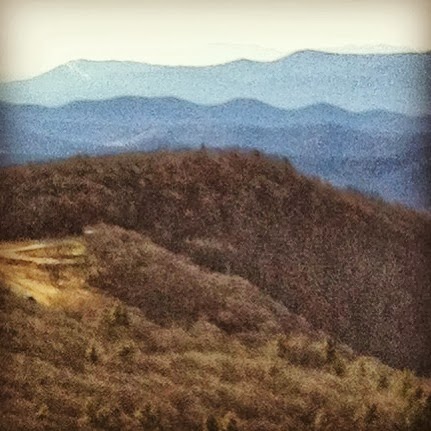
For Sunday's trip, I decided not to climb the talus slope to the top.  While I was out for a leg stretcher, I really wanted to try out the panoramic feature on my iPhone, so I was looking for some photo opportunities.  Once I've had a look at those I may post them, but for now I selected three scenic photos - one of the talus slope or "river of moving rock" as NPS called it, a second of the little trail that moves off to the northwest towards Trayfoot mountain, and a third of the main summit and talus slope.

All in all a great day - I can't say enough good things about this particular day hike.

Friday, August 12, 2016

Stonyman in Summer

Mary's cousin was down for a visit for a week or so, and after a few days in Alexandria we headed to the Valley for the weekend.  It's summer, so there's a spate of outdoors activities scheduled for any given Saturday and Sunday - of course we took those in.

At the end of her stay there was one thing left on the to-do list and we decided to go up into Shenandoah National Park to take in some views and to enjoy the cooler temps at altitude.  We chose the interpretive trail at Stonyman, a 1.5 mile loop with about 350 feet of elevation gain.

That qualifies it as an easy day hike, certainly, but this remains one of my favorites, and I have done it some dozen times, in all seasons.

Even though it was Sunday, the trail was not crowded as it can get.  We weren't the only folks at the main summit, so after a few minutes there we walked down the horse trail to the other outcropping, and we had that spot to ourselves.

I took this photo looking northwest out onto the Valley below, Luray is just visible in the mid-ground, with Massanutten Mountain behind.

With the hike behind us, we headed back to Hawksbill Cabin for some lunch and then it was back to the city - and ultimately our trip to NYC, which I posted about last week.

Wednesday, June 1, 2016

Shenandoah National Park Views from Above and Below

 A few weeks back I found some time on Sunday morning to take my first trip of the spring up to Skyline Drive.  We were destined for our first sunny day in the 80's, so I thought I might find a view to look down at our lovely Valley.

I settled on Blackrock Summit, which is the southern peak of the little saddleback that hosts Big Meadows Lodge up in Shenandoah National Park.  They say you used to be able to see the lodge from the brick terrace at Hawksbill Cabin, but the trees have grown in now and it is obscured.

That's no problem - a view of the peak hangs over the road into the neighborhood, so I'm reminded of it's proximity nearly every time we visit the house.

As it turns out, the next weekend was the annual spring planting event at our neighbors' Wisteria Vineyard.  While I had some chores to take care of at Hawksbill Hop Yard, Mary wanted to go and work in the vineyard to plant some of the new vines, so I dropped her off and headed over to the farm.

Later, when I came by to pick her up, the group was socializing out in the vineyard, near a spot where there is a great view of Blackrock Summit and the lodge.  So I took a short walk over there and snapped a photo of it, enjoying the symmetry of the experience I'd had, visiting there last week to have a look down at the Valley, and now having a look up at the peak.


One final one - on the way to the summit that day, I stopped at the Pinnacles Overlook on Skyline Drive to take in another favorite view.  This one is of Old Rag, which stands off to the east of the drive.

These days we're keeping too busy to visit the Park as much as I'd like.  Instead, I'll treasure the short time I do get to spend there - and these photos will help me to do that.

Friday, April 15, 2016

The Bees Have a Good View

On Sunday I decided that Tessie and I should drive over to Hawksbill Hop Yards and scout for progress on the bines.  While it's early in the season - May 14 is the frost free date in the Valley - I wanted to see how things were going.  And since the dog was along, we took a walk out into the other fields at Public House Produce once the scouting trip was over.


Just across the little drainage from the hop yards is an "idle" field - at least it appears that way.  But at the produce farm this field has two key purposes - one, it's a key forage area for the bees that will be busy pollinating the crops later in the season, and two, it's a food patch that serves to keep some of the deer at bay from the other crops.


With the proliferation of the varmints, you could argue whether or not it's a success in that second role, but as far as the first goes, I think the bees are happy.


David has a cover crop in right now that will serve to nourish the bees in the early going.  As Tessie and I walked along I noticed the incredible view of Stonyman Mountain in Shenandoah National Park just over there in the distance, so I had to stop for a moment to admire it.


Then as we turned to walk back to the hops, I went to have a look at the apiary.  It was too cold for much activity in the hives, so I was able to get close.  I had to cajole Tess a bit to keep her away from the electric fence, fortunately this was a listening day for her and she didn't get a "life lesson."

But that could happen some day - I wouldn't bet against it.

Thursday, November 12, 2015

Hawksbill Summit - November 2015 edition


Besides hitting a deer midway through my vacation in the Valley, I had the opportunity to get out for a little day hike, choosing Hawksbill Mountain in Shenandoah National Park as my destination (link here).  

As I drove to the park and then along Skyline Drive, I calculated in my mind that this was the first time this year I had been in the park – so I resolved to savor the trip and see if I could get a few good photographs.

Included in the post are some panoramic views of the Valley, taken from the drive as I passed milestones on the way to the trailhead – including Stonyman (wikipedia link), and the approach to Hawksbill (wikipedia link).  I’m including the shot I always love to get of Old Rag (wikipedia link)from the summit, as well as one of the evergreens that can be seen along the trail.  


We’ve had a stretch of unseasonably warm days, Indian summer style.  The change left the air clear of haze, and gave unusually clear views of the valley below.


The Hawksbill Summit trail I most often take starts at the upper parking area and is a 2.1 mile out-and-back route with 520 feet of elevation change (there are a couple of up-and-downs, so the net gain is less, around 400 feet).  I consider it an easy day hike – it’s a leg stretcher I enjoy whenever I have the time for a short hike in the park, with some incredible views from the summit.


I was really glad to check the box on a trip to the park this fall.  I hope that I’ll have another chance later this month or early December, weather permitting!

Friday, March 20, 2015

Hawksbill Hop Yards - Progress Report

There is a lot going on at the hop yards these days - David sent along a report on Thursday evening showing the clear ground.  That's just about the end of our current stage of activities, just a couple of steps to go - rolling a disc through the soil to break it up, and then soil amendments.

To get that part right, we'll be looking at pH, which should be between 6.0 and 6.5 - and if needed we'll boost with lime.  For potassium and phosphorous, he plans to spread chicken litter.  Of course, N is important as well, especially for hops, and that is the final one of the "big three" we'll be getting a look at.

To be sure we get it right, there have been a few conversations with the extension agent.  There's good interest from the state in this crop and we know they will be there to support.

In the first photo above, the view is looking at the yards from the northwest - in the background, you can see the Blue Ridge in Shenandoah National Park.  The second peak from the right is Hawksbill Mountain, the highest point in the park, and the namesake of the hop yards - also the namesake of a bunch of other stuff in Page County and Luray!

The second photo was taken a few days ago, just after the clocks were adjusted forward.  With the extra daylight, David took a photo in the fields at dusk.  In addition to the hop yards, this new ground is going to be planted with more of those wonderful Public House Produce vegetables - and that's something we can all look forward to!

Summer's not far away at all, people!

Friday, June 20, 2014

Tessie's "AT Section Hike" Adventure

Tessie is conditioned to think that anytime I pick up the car keys while we are at Hawksbill Cabin, she is going for a ride.  On weekend mornings she has a pretty good chance of being right - but at other times, it's just as likely I'm heading out there because I forgot my phone charger.

However, last Sunday morning she was right, and we went out for a walk of a mile or so on the Luray Hawksbill Greenway.  We got back after and hour or so and I went to work writing - that came easy to me, so I finished earlier than I expected.  I decided we might head up to Shenandoah National Park for a short hike.
 The parking lot at the trailhead I wanted to go on was full, with spillover traffic on the shoulders, so we passed on.  I settled for the Pinnacles picnic area instead, with the thought we might explore a stretch of the AT in the direction of Mary's Rock - no plan for how far we'd go, just a leg stretcher and to keep Tessie trained on how to walk on leash in those conditions.

Off we went, her leading the way - she is a border collie, after all.  There was an easy leg on this hike, about 3 tenths of a mile and negligible altitude changes, to Jewell Hollow overlook.  I decided we'd keep it short and I'd work with her coming up on the rocks there with me, and on walking carefully on brick walls.

We did take a little side trail for another tenth of a mile maybe.  All totaled, 8 tenths of a mile or so, and then negligible altitude change.  We did get to take in a wonderful view of Page Valley, with Lake Arrowhead in the foreground, and she had quite a few good sniffs along the AT.

One thing I've come to enjoy about stretches of the AT in the vicinity of Thornton Gap - that is the construction of the trails.  Although the main tread areas can be well worn, often the masonry has held up very well, considering some of it was laid down in the 1930's by the CCC.  You can see this along the right side of the trail in the photo above - nicely mitered edge to that border.

This was Tessie's fourth hike in Shenandoah National Park.  It's fun to think about this as an actual shakedown for a longer day hike with something that could seriously be called a section - say 10 miles or so.  I'll have to think about how we would provision it, and maybe we'll take something like that on in the fall.

Tuesday, May 6, 2014

Trillium Spring

As we were loading the car on Sunday night, I happened to catch a glimpse of a pinkish white flower over in the part of the Hawksbill Cabin yard that we leave to nature, between us and the neighbor.  It is a trillium, specifically trillium grandiflorum, and I was surprised to find it there, since we've never had one before that I can remember.

Trillium is a native understory plant in Appalachian woods.  The timing of its appearance is generally during the month of May in our area, and there is a linkage to the cycle of deciduous trees in the woods.  I once hiked Hightop Mountain in Shenandoah National Park looking for them, but was too late in the season to see many.  (If you are interested in that hike, click the Easy Day Hikes label and search for it.)

Luckily, now it looks like we'll have our own trillium at Hawksbill Cabin. It's a rhizome plant, and according to the Wikipedia article I've linked below, it forms clonal colonies.  So we can hope for its return next spring, and for more of them.

Here are a couple of links for more info on the flower:
http://www.nps.gov/shen/naturescience/wildflowers.htm
http://en.wikipedia.org/wiki/Trillium_grandiflorum

Also, here's an Amazon link to a nature guide about our area near Shenandoah National Park:

Wednesday, April 9, 2014

Jones Run Falls - More Photos

In the post yesterday, I mentioned I had a couple of photos and such, taken with my new iPhone 5s, that I wanted to share.  Let me start off with a photo of Tessie and me, which Mary took of us down at the falls. Good times! 


Next, here's ten second video of Jones Run Falls.  At 42 feet, this is not the tallest in the park, but still it's pretty grand. This was my fourth hike down to it - I think it has become my favorite in the park.


Here is the first of a couple of panoramic shots I took, using that feature on the iPhone.  The first one is of one of the two falls you reach before you arrive at the main falls - there's a cave and some pretty interesting rock formations in this part of the gorge. Even though the waterfall here hugs that large boulder, there is plenty to take in at this spot.


The final shot here is a panoramic view of the main falls.  It shows how the falls plunges over a rock ledge through this part of the gorge, and the abstraction from the pano feature makes for an interesting perspective.


Tuesday, April 8, 2014

Jones Run Falls - an Easy SNP Day Hike

Over the course of the last week, I read somewhere that the waterfalls throughout Shenandoah National Park were at their peak because of the recent heavy rains, which followed a snowy winter.  I asked Mary if she thought she might be up for a hike to check out a waterfall or two, suggesting we might go to Jones Run Falls in the South District, which has become one of my favorite waterfalls in the park.  We set off on Sunday morning, with Tessie coming along for the hike, and on the way to the trailhead we saw lingering snow in the shadows along Skyline Drive.

As I prepared to write this post, I took a minute to recall my previous hikes to Jones Run Falls, trying to figure out why I like this waterfall so much.  I’ve linked a couple of the old posts below – they’re full of photos of the scenery, and that is certainly part of what I like so much.  It could also be that the cascades along this stream, along with Doyle’s River, are so accessible to hikers – you can literally walk right up to them if you want, and even jump in there for a shower if you like.

While I have done the Doyle’s River/Jones Run circuit before, we agreed that we weren’t up to a hike as rigorous as that.  Instead we chose to simply hike down the Jones Run gorge from the trailhead at milepost 84, a descent of 900-plus feet and a round trip of 3.4 miles.  The combination makes it an “easy” hike in my book, it needs to exceed 500 feet of elevation change and five miles of distance to be moderate.

The fact that there are three waterfalls and two stream crossings on this short hike makes it a very worthwhile outing.  While there are no rock scrambles or other features of that sort, the jumbled formations of boulders strewn about the gorge offer some pretty great views as well.

Mary, Tessie and I had a nice walk together, and spent about an hour enjoying the falls once we reached them.  A couple of family groups were out for the day, and everybody wanted to give Tessie some attention.  That’s a canine who knows how to work it.

In addition to the linked posts below, I’ll be making a second post about this hike – I wanted to use a couple of the iPhone photo features, and I’ll share a couple of extra photos tomorrow.

As I mentioned, here are some previous blog posts about this hike:

Monday, December 30, 2013

Stoneyman Summit, with Ulterior Motives

At the Stonyman summit.  Luray is just behind Mary
and me, and Lake Arrowhead is center right. The furthest
ridge is Great North Mountain, in WV.
It's probably just coincidence, but since we have been coming to Hawksbill Cabin, Mary and I have taken a couple of hikes in Shenandoah National Park on the last weekend in December or the first in January.  We continued that tradition with a short hike to the Stonyman summit last Saturday.

It was a great day for a hike, with clear, bright skies and warm temperatures, so the time was right.  But as the title of this post suggests, I had a couple of other ideas about the hike - for one thing, I wanted to try out my new Casio Pathfinder watch.  The other motive will be the topic of my next post.

The Stonyman hike is short, only 1.5 miles, and the elevation change is about 330 feet.  It qualifies as an easy one in my book - but it does end with one of the best views of Luray and the Page Valley that you will find in the Park.  Stoneyman is the second highest peak in the Park, by the way, at 4,010 feet - and on a clear day like Saturday you can see all the way to West Virginia.

The white blaze marks the route of the Appalachian Trail,
while blue blazes mark other routes throughout SNP.
Despite its shortness, this is one of my favorite hikes in the park.  It is close to the Skyland resort, so it was designed as an interpretive trail - there's a guide and marked stops to curate the walk in the woods - and there is a horse trail near the summit that marks a second vista that is often less crowded than the main observation point.

When I first found the trail, one of fondest discoveries was the twin blazes that mark the route: white for the Appalachian Trail, and blue for other hikes in the Park.  There used to be a sign where the routes diverged, about halfway up; I think that it said that point was the highest spot on the AT within the Park boundaries.  I need to go back and look through some past posts to remind myself, I know I have posted a photo of that old sign.

View to the Southwest, across Skyland Resort.
The peak in the upper left is where Massanutten Ski
Resort is, and you can just see the trails.
Using the new Pathfinder, Mary indulged me while I took measurements at three spots on the trail:  at the trailhead, at the point where the AT splits away, and at the summit.  Some features have changed since I had my last watch, but from experience I knew to take a reference altitude from a marked location, in this case the summit, at 4,010 feet, to calculate the climb.  I calculated a net gain of 326 feet, and for now that will be the high point record with the watch.

While we were at the summit I told Mary about the first time I took this hike, back in the days when I was checking off all the "Easy Day Hikes" routes (obligatory Amazon link below).  I got the horse trail summit and sat down to enjoy the view when my cell phone rang.  I spent 30 minutes on a work conference call up there that day, even though I was on vacation - you can bet I billed for that call!

The trail wasn't crowded, but we weren't the only ones who had the idea to go out on a hike. We enjoyed meeting a young family, a mother and daughter out on a walk, and then a couple from New Jersey (Red Bank - exit 109).  But as I mentioned, there was one other purpose for getting out on this hike, and I will post about that next.


By the way, here's the link to the Best Easy Day Hikes book I mentioned above:
Best Easy Day Hikes Shenandoah National Park, 4th (Best Easy Day Hikes Series)
It's not my only guide to the park, but I do refer to it frequently.


Monday, November 18, 2013

"75 @ 75" Project - a Wrap

Selfie on one of the first 75 @ 75 hikes to
Overall Run.
Yesterday I needed to replace my dog walking shoes, and I really like the Patagonia Men's Drifter A/C Hiking Shoe.  As I browsed the hiking books at REI, I was reminded that my last post on the “75 @ 75” project was a year ago, and I never met my objective for this initiative.  I guess it is time to write some wrap up posts and move on.

I designed the 75 @ 75 project to be a series of hikes I planned to take as a way to honor the 75th anniversary of the founding of Shenandoah National Park.  The hikes chosen were moderately strenuous, at least five miles in length and including a net elevation change of at least 500 feet.  Even though I have completed quite a few hikes in the park that did not qualify by this definition, my final status on the project (shown in the accompanying table) was seven hikes completed with total mileage of 54.8 miles. 

I simply ran out of time for the project, since these were all to be completed in the 2011-2012 timeframe to coincide with the park’s anniversary.  I plan to continue to check the box on the hikes from my original list, but since they will be done outside of the timeframe for the project, it’s time to put an end to 75 @ 75. I want the closure. 

Here’s one of the lists (sourced from the Heatwole guide, which is now out of print and not even available on Amazon at the moment) I compiled to identify appropriate hikes. The hikes in bold were completed during my 75 @ 75 attempt.

  • Hike 1 - Bluff Trail/AT, mile post 17.6, distance 12.8 miles, altitude change 2,400.  Includes two summits and some views, and about 5 miles on the AT.
  • Hike 2 - Piney Branch/Piney Ridge, mile post 22.1, distance 8.3 miles, altitude change 1,700 feet.  This one includes a mountain cemetery, old homesite, stream crossings, and a small waterfall. 
  •  Hike 3 - Knob Mountain/Jeremy’s Run, mile post 24.1 (at the Elk Wallow Wayside), two versions either 11.7 or 14.0 miles, elevation from 2,600 to 2,800 feet.  There’s a stream with cascades and a falls, and a summit.
  •  Hike 4 - Hazel Mountain, mile post 33.5, distance 5.3 miles and elevation change 1,070 feet (the easiest on this list!).  No summit here, but it is interesting for a combination of a falls, cascade, and a small cave.  Depending on when we go, maybe no spelunking – the snake scene in True Grit still creeps me out.
    Staircase on the Hazel Mountain trail.
  • Hike 5 - Pocosin Mission and South River Falls, mile post 59.5, distance 8.5 miles and elevation 1,800 feet.  This combines the ruin of an old cabin and mission, and then takes in the South River Falls, which was one of Chris’s and my main training hikes for the Half Dome a few years ago.
  • Hike 6 - Black Rock/Trayfoot Mountain Loop, mile post 84.8 or 87.4, distance approximately 10.0 miles and unestimated altitude change.  This trail is shown on one of the Park’s maps, which include distances but not altitudes.  This will take in the rock scramble at Black Rock, an old fire observation point on Trayfoot Mountain, and the hollow where the Black Rock Springs Hotel was located in the late 1800’s.
  • Hike 7 - Riprap Hollow and Wildcat Ridge, mile post 90.0, 9.8 miles and 2,400 feet.  Includes the two Civil War lookout points Chimney Rock and Cavalry Rock, 3 miles of AT section, cascades and a falls.
  • Bonus Hike (8):  Hannah Run and Hot-Short Mountain, mile post 35.1, 9.1 miles and 2,800 feet.  This one includes ruins of mountaineer cabins and a stream.

Friday, September 6, 2013

South River Falls: An Easy SNP Day Hike


Seems like I haven’t been up in the Shenandoah National Park much this year, so on Sunday I decided to take Tessie and head up for a little hike.  I hoped it would turn out better than the last one – we got rained on, and she had the most pitiful look ever in the car after.  We took a little drive to Elkton and took the short drive north to the South River Falls trailhead.

Heatwole describes this hike as 2.6 miles roundtrip, total climb of 850 feet, and about 2:15 in duration – that’s all pretty accurate in my book.  The hike qualifies as a moderately easy one by his rating, and by mine, because I like to see 5.0 miles and 500 feet before I consider a hike moderate. 

Along with not getting to the park as much this year, my exercise has tapered off too.  Where I used to walk Tessie a mile a day and then added 1.5 miles of walking back and forth to the subway, I’m down to the dog walk and maybe ½ mile of walking back and forth to a shopping center for lunch.  With the entire climb facing us on the return trip to the car, both the dog and I suffered on the second half of this one.

We took in some nice forest views on the way down, and I made a video of Tessie as she experienced crossing a stream that was hidden away under some rocks.  I’ll upload that at another time.  The outward leg of the hike ended at the little overlook with a view of the falls.

While Tessie and I took a break there, I was remembering that Chris and I did an extended version of this hike a few times when we were preparing for the Half Dome hike in 2005.  That route goes all the way to the base of the falls, and Heatwole has it as 4.7 miles with a climb of about 1,315 feet – so it still wouldn’t qualify as moderate by the standards I use today, but it was an effective early hike for us as we undertook the preparations for Half Dome.


I think the dog had a good time, despite our struggles on the return, and the time outside certainly inspired me to want to get back to the park more often this year.  I even bought a new annual pass, good until next September!

Monday, June 17, 2013

Hawksbill Mountain Day Hike

Looking south from the Hawksbill Summit.
It’s something of a ritual, whether it occurs in the spring, summer, or fall – but Mary and I find our way to the summit of Hawksbill Mountain in Shenandoah National Park at least once a year.   Most recently, that was during our vacation in late May. 

Lately, another part of the ritual for me is a stop at the Pinnacles overlook, where you can get a nice view of Old Rag, site of one of the most popular hikes in the park – for more on that, check out Bob Look’s blog in the blog roll on the right.  He’s a volunteer steward on the mountain, and is a source of a wealth of information about the trails, the wild life, and other goings on up on Old Rag.
Old Rag, from the Pinnacles Overlook.

We chose the route from the Upper Hawksbill Parking, at mile 46.7.  My Heatwole guide describes the hike: “Round trip 2.1 miles, total climb about 520 feet…A fairly easy hike on a graded trail and a fire road.  Good views from the summit.”
Page Valley below, from Hawksbill Summit.

I’m sharing a few photos from the summit with this post – the views are one of the reasons we go there so often.  But sometimes we go for the breeze, especially during the summer, because Hawksbill is highest peak in the park and it’s usually a few degrees cooler up there.

This hike will take you anywhere from 2 to 3 hours, depending on how much time you spend at the summit enjoying the 360-degree views or watching the hawks and buzzards gliding by.  There are often deer along the path, and there are always chipmunks and squirrels scavenging away in the underbrush just out of site. 


Since we can see Hawksbill Mountain from the cabin during the winter, I guess you could call this easy day hike a favorite.

Monday, December 3, 2012

Hazel Mountain, a 75@75 Hike


I’m overdue for a post on the status of my “75@75” project – this was the effort I’d planned where I hoped to hike 75 miles to celebrate the 75th anniversary of the founding of Shenandoah National Park.  I was going to get this done by May 2012, but I’m still working on completing it. 

Late summer of this year, Chris and I got together for a hike and he agreed we could try to take on one from the 75@75 list – Hazel Mountain.  Here’s the entry I wrote about this hike as I began to plan this project:

·         Hike 4 - Hazel Mountain, mile post 33.5, distance 5.3 miles and elevation change 1,070 feet (the easiest on this list!).  No summit here, but it is interesting for a combination of a falls, cascade, and a small cave.  Depending on when we go, maybe no spelunking – the snake scene in True Grit still creeps me out.

The day Chris and I took this one on, in September, I’d forgotten my Heatwole guide and other materials related to the hike.  So, what we did was a hike that was actually longer in distance – I’m estimating that we did about 6.5 miles on the route, but the elevation achievement was more on the order of 660 feet, just taken from the readings on my Casio Pathfinder.  Also, although there was a stream crossing, and it was clear we were moving through an area of second growth forest that had previously been settled and farmed, we didn’t see a waterfall and didn’t come close to anything resembling a small cave.

We used the map provided by rangers at the entry station to devise a hike. Of course, the map didn’t include the kind of detail that you find in the Heatwole guide.  Still, we had a nice day of it out there, and found the break from some of the more rigorous hikes we’ve done in this series to be very welcome.

Heatwole’s guide suggests that we may have passed the site of the old Hazel School somewhere along the way – he describes an overgrown area that I remember passing by and making a note of it to Chris on our hike.   It was one of several areas that we passed that had this appearance, as I recall; Heatwole says this area was one of the more heavily populated areas in the Park.

It was definitely a good time of year to be out on a hike – the forest was still very much a greenscape, and there were butterflies out all along the drive.  I’ve got a photo here of a yellow swallowtail we saw at the trailhead.  The hike qualifies on distance and elevation as moderate, by my standards – requiring five miles in distance and at least 500 feet of elevation change – but it is not particularly noteworthy as a physical challenge.  Instead, I’d give it high marks simply for the experience of being outside in the Shenandoah National Park, which is a kind of therapy in itself, and a part of what I’m seeking with all of these hikes in the first place.

On the way back, I made a point of taking a photo of Old Rag from the Pinnacles area where there is an overlook that provides a good view.  Seems a long time now since I’ve been on that mountain, but a summit from August 2011 is included in the 75@75 project.  As a note, here’s my progress chart on the project:


I’m posting this today to start the month of December – to date I have completed 54.8 miles out of my originally planned 75 miles.   Chris and I are tentatively planned to get in the Buck Hollow trail later this month – that’s 6+ miles; and if we have enough daylight we may summit Mary’s Rock from the Meadow Spring Trailhead, for a total of 9.1 miles.

If we are successful, this approach to the Mary’s Rock summit would check off another list for me – the 4th edition of Best Easy Day Hikes includes the southern approach as one of the routes, and it is one I haven’t been on yet.  If we complete that whole hike, which is admittedly aggressive, I will still need to complete more than 11 miles to be able to report the completion of my project.  

I’ll keep working on it, even though in the end it is probably going to have taken me almost two years to complete!

Friday, November 9, 2012

Snow on the Mountain

One of the things that made Hurricane Sandy such a devastating storm was the combination of two wintry systems with the tropical one.  While the full force of that storm was felt in New Jersey and New York, we had some impact in Virginia.

And as the news of the storm began to reach Mary and me in Alexandria, one story I saw was that as much as a foot of snow was getting dumped up in Shenandoah National Park.  Skyline Drive was closed, but in the typically beautiful weather that follows a storm like this one, the park was soon reopened.

I'd seen that there were major accumulations at Big Meadow, which is in the part of the park with the highest elevations.  The lodge there is only four miles away from Hawksbill Cabin - as the crow flies - and about 3,000 feet above us.  The story goes that before the trees grew in to our neighborhood, you could see it from the brick terrace.

So Mary and I took a drive up to the park, and I wasn't disappointed in my search for early season snow.  These first two photos are from the Jewell Hollow overlook, looking down into the Valley.  You can catch a glimpse of Lake Arrowhead to the west in one of them.

The final picture I'm sharing today is a view of the Big Meadow area from the nature center across Skyline Drive.  Sure enough, this is where the largest accumulations were - it was chilly enough up there for the snow to stay down.

While we didn't walk out into it, it was the inspiration for another treat: we went over to the camp store there and had a hot chocolate before we got back on the road home.

Monday, October 29, 2012

Fall Foliage Photos

The view from Balkamore Hill, just north of Stanley, VA.
Well, here we are hunkered down during Hurricane Sandy.  I was thumbing through the photos I have saved on my phone and realized I hadn't put up some of the foliage highlight shots I took last weekend when we were out at Hawksbill Cabin.  This weather is going to hasten the end of the foliage - as you can see by the Skyline Drive photo I've put in at the end of the post - but for now, it's good to remember it in the face of this week's apocalypse.

The first photo is the one from up on Balkamore Hill - where the bike races take place.  I often take that route as part of my drive back from the park with Tessie.  It was a nice view with the fall colors last weekend.

Back in the wood lot, looking up through hickories and oaks.
Another of our rituals during the fall and winter is a walk back into the wood lot.  I don't do this in the spring and summer when the snakes are on the move, even though Tessie will stand at the beginnings of the path and wait for me to come along.  We have a lot of hickories back in there, their golden color making a highlight.

Dogwoods and the still-green apple tree in the front yard.
In the front yard, we have some nice trees of species that are well known for their foliage, including a dogwood or two.  Here's a peak at them from the driveway, with the little patio off the main bedroom just in the view on the left.  The strong angle of the sun required me to stay in the shadow of the house.

It's a pity, but with the rain, wind, and possible wintry mix of precipitation, the leaves will be all but gone when we're next out.  But we'll see about that!

Closing out the post today, here's a photo I clipped earlier from the Internet.  It's from one of the Skyline Drive webcams, near Big Meadows (which is only four miles from Hawksbill Cabin as the crow flies, and about 3,000 feet above it).  As you can see, they're getting snow up there today - the forecast said anything above 1,500 feet would - and the drive has been closed.

Brr!  And it's not even winter yet!

Big Meadows in Shenandoah National Park, via webcam, 10/29/2012.