Ramble On

Showing posts with label Day Hikes: Easy. Show all posts

Tuesday, January 24, 2017

Hawksbill Summit Hike - December 2016

How many times have I written about Hawksbill Mountain on this blog?  According to the labels list to the right, the answer is more than 20 - it's probably just an indication of how special the place is to me.

Since we've owned Hawksbill Cabin - basically that's when the blog started - I've hiked that mountain at least a dozen times.  It's a short, inspiring hike to the summit, a perfect leg stretcher when you need to get your mind around a major home repair, like when we had to replace the cabin's roof.

During my time off over the holidays, we had some family visiting in Luray, and my niece and nephew decided to take the hike with me.  Actually, I needed to go up there for some brewery research, and I managed to talk them into it.

The brewery is named after this mountain.  We've been working on the logo for some time but have found it challenging to make progress for a couple of reasons.  The brewery team wanted to see some images of the structure and views from the summit, so I decided I would head up there to get some photos.

When I write about the hikes, as I did in November 2015, I typically describe it as follows:

From the upper parking area, the Hawksbill Summit trail is a 2.1 mile out-and-back route with a net elevation gain of 400 feet (520 feet if you count the ups-and-downs).  I consider it an easy day hike – it’s a leg stretcher I enjoy whenever I have the time for a short hike in the park, with some incredible views from the summit.

The hike up to the summit takes less than a half hour, and on this occasion, we stayed at the summit for about that much time.  Our little excursion was less than two hours overall, but it was enough to refresh us.  

Plus, I got the photos I needed.  We'll see if these get worked into the final logo.  In any case, mission accomplished.

Thursday, September 22, 2016

Revisiting SNP's Black Rock

Since I first discovered the Black Rock Summit hike in 2009, it has been one of my favorites in Shenandoah National Park.  At about one mile round trip and less than 200 feet of altitude gain, it's one of the easiest hikes I go on - and I've been back there five or six times.  The experience of this summit seems like such a great reward for such little effort expended.

I've written about the hike a number of times for this blog as well:


The NPS is observing its centennial this year, and it appears that they have made some enhancements to this hike at the trailhead.  There's an interpretive sign about the AT there now, and there is a little activity guide for kids, describing what they will see on the little hike.


The sign at the trailhead was also updated.  It now includes a substantial description of the geology of the place:


"The exposed rocks of Blackrock formed the seabed of the Iapetus Ocean, an ancient body of water that predates the Appalachian Mountains.  The geological forces that created the mountains changed the seabed into solid quartzite rock. ... Blackrock is still changing.  Weathering has caused what was once a cliff to crumble into a talus slope, a river of moving rock.  Water, ice, and roots break the rocks into even smaller pieces that slide downhill.  Eventually the rocks will have settled enough that plants can grow and Blackrock will look like other forested mountainsides."


The old seabed is in evidence elsewhere in the SNP, but you can also catch a glimpse of it in a number of other places in this region:  Massanutten Mountain's Duncan Knob has a very similar geology, as does Seneca Rocks in West Virginia.  There are also fields with large talus features in the Dolly Sods Wilderness.

For Sunday's trip, I decided not to climb the talus slope to the top.  While I was out for a leg stretcher, I really wanted to try out the panoramic feature on my iPhone, so I was looking for some photo opportunities.  Once I've had a look at those I may post them, but for now I selected three scenic photos - one of the talus slope or "river of moving rock" as NPS called it, a second of the little trail that moves off to the northwest towards Trayfoot mountain, and a third of the main summit and talus slope.

All in all a great day - I can't say enough good things about this particular day hike.

Friday, August 12, 2016

Stonyman in Summer

Mary's cousin was down for a visit for a week or so, and after a few days in Alexandria we headed to the Valley for the weekend.  It's summer, so there's a spate of outdoors activities scheduled for any given Saturday and Sunday - of course we took those in.

At the end of her stay there was one thing left on the to-do list and we decided to go up into Shenandoah National Park to take in some views and to enjoy the cooler temps at altitude.  We chose the interpretive trail at Stonyman, a 1.5 mile loop with about 350 feet of elevation gain.

That qualifies it as an easy day hike, certainly, but this remains one of my favorites, and I have done it some dozen times, in all seasons.

Even though it was Sunday, the trail was not crowded as it can get.  We weren't the only folks at the main summit, so after a few minutes there we walked down the horse trail to the other outcropping, and we had that spot to ourselves.

I took this photo looking northwest out onto the Valley below, Luray is just visible in the mid-ground, with Massanutten Mountain behind.

With the hike behind us, we headed back to Hawksbill Cabin for some lunch and then it was back to the city - and ultimately our trip to NYC, which I posted about last week.

Thursday, November 12, 2015

Hawksbill Summit - November 2015 edition


Besides hitting a deer midway through my vacation in the Valley, I had the opportunity to get out for a little day hike, choosing Hawksbill Mountain in Shenandoah National Park as my destination (link here).  

As I drove to the park and then along Skyline Drive, I calculated in my mind that this was the first time this year I had been in the park – so I resolved to savor the trip and see if I could get a few good photographs.

Included in the post are some panoramic views of the Valley, taken from the drive as I passed milestones on the way to the trailhead – including Stonyman (wikipedia link), and the approach to Hawksbill (wikipedia link).  I’m including the shot I always love to get of Old Rag (wikipedia link)from the summit, as well as one of the evergreens that can be seen along the trail.  


We’ve had a stretch of unseasonably warm days, Indian summer style.  The change left the air clear of haze, and gave unusually clear views of the valley below.


The Hawksbill Summit trail I most often take starts at the upper parking area and is a 2.1 mile out-and-back route with 520 feet of elevation change (there are a couple of up-and-downs, so the net gain is less, around 400 feet).  I consider it an easy day hike – it’s a leg stretcher I enjoy whenever I have the time for a short hike in the park, with some incredible views from the summit.


I was really glad to check the box on a trip to the park this fall.  I hope that I’ll have another chance later this month or early December, weather permitting!

Friday, September 5, 2014

Mendocino Day Hike - part 2


Mary and I are familiar with the groves of Coastal Redwoods that dot the west coast from south of the Bay Area up to Oregon.  We've taken a walk through Muir Woods - one of the National Parks in Marin County, driven through some of them on trips to the coast (there is a 10-mile stretch of route 128 from Healdsburg to Mendocino that winds through one grove), and we've taken horseback rides through another one on the North Coast.  So as we left the pygmy forest, we looked forward to the descent down to the stream bed and the grove that we knew was down there in the ravine.

These trees are considered the world's tallest - they routinely reach 300 feet tall, and the tallest is around 380 feet.  That's about 30 stories or higher.  Giant Sequoias, which stand along the western slopes of the Sierra in Central California, are the largest trees, although they are not as tall as the redwoods.

Depending on the characteristics of the ravine they grow in, it can be quite dark on the forest floor in a redwood grove, but that wasn't the case at Van Damme State Park.  The ravine is not as narrow as some, and there has been a history of harvesting trees, so what we found was pleasant, patchy sunlight. The conditions made for a nice under story of ferns and redwood samplings, although we also spotted a few hardwoods mixed in - and plenty of blooming wildflowers, it being late May.


They can grow from seed, but often these trees grow in what I like to call "family groups" - small trees sprout from the root system of mature parents.  You see them forming a large ring of related young trees around a much larger tree.  Here at Van Damm, a lot of the parent trees had been harvested, leaving the young ones crowded around a stump.

Here's a web site with additional information about the Coastal Redwoods - http://www.savetheredwoods.org/redwoods/coast-redwoods/ - a visit, to a grove is a humbling experience, always reminded me of the temporary nature of our human condition.

I'll close out today and the posts about this 5-mile day hike in Mendocino with a final photo.  It shows how the coastal terraces in this region evolved into this modern phenomenon, with the pygmy cypresses, barely six feet tall, at the higher elevations, and these giant redwoods so close by only a hundred feet or so down the canyon.

Thursday, September 4, 2014

Mendocino Day Hike - part 1


I was looking through the photos on my phone and found some from our May trip to Mendocino, so I thought I would put up a two-part post about the day hike we took to Van Damme State Park, located just a few miles south of Mendocino along Highway 1.  Of course, you pass by the typical coastal scenery to get there, so as a reminder, I'll open with a photo of the bay at Mendocino, taken from the headlands.  The previous posts on this trip can be found under the label "Vacation 2014" below or in the list to the right.

By the time we settled on this adventure we had been in the area a few days, already enjoying trips up to Fort Bragg to see the Glass Beach, taste the beers at North Coast Brewery, and generally enjoying all the things we love about the area from past vacations.  The inspiration for the day hike was to make our way into one of the coastal red wood groves which populate this part of the country - we saw plenty of the big trees on the hike, but that will be the subject of part 2 of this post.


The irony of the Van Damme experience is that it is also an unique ecosystem of small trees - the Mendocino Cypress.  In an earlier trip, we had hiked in Jug Handle park and learned about how the terrain was formed in a series of terraces as the land rose out of the sea.  Here in Van Damme, you experience four of these terraces, with the highest ones characterized by exceptionally poor soils.

The impact of the poor soil is not only a lack of nutrients, but also dry, compacted conditions which make it hard for the roots of the trees to gain purchase.  So the Mendocino Cypress stays small - hardly any of them were more than six feet tall - which actually conceals their age.  As the interpretive sign here says, a tree that is a quarter inch in diameter and two feet tall may be over 80 years old!


There is a nice boardwalk that has been constructed through this part of the trail to navigate through the forest and enjoy the view of these bonsai-like trees.

I realized after taking the photos I don't have anything in the frame to provide a reference on the height of the trees, but few of them extended to the height of the hand rail on the boardwalk.  Most of them were between four and five feet tall, with a few getting up to six feet.

At this altitude, maybe 200 feet above sea level, it was very sunny and dry.  We were probably a mile or two inland to start the hike, so we were finding a climate that is not atypical of northern California.


One of the stories of this trail, which we would follow for about 5 miles round trip and descending to sea level is the micro-climates that you progress through.  The dry hot conditions in the "pygmy forest" were night and day compared to the conditions we experienced as we began our descent.  That's where I'll pick up tomorrow for part 2.

Wednesday, July 30, 2014

The C&O Canal Towpath - an Easy, Work-Related, Day Hike


For the vast majority of posts on this blog, I’ve avoided posts about work.  Sure they work their way in from time to time, as they did when I traveled more often – see the "road trips" label, where I wrote about my Japan trip or my last Yosemite trip, for example; but still it’s an infrequent occasion.  And I would never have expected to do something blog-worthy at my current position, as a program manager on a construction site…


We have started working in earnest on some storm water management concerns, and for two or three months we’ve known that we were going to have to follow our watershed channels down to the C&O Canal and the Potomac.  That day finally came a few weeks ago on a Friday – we’d planned ahead so we could dress appropriately for a hike into the woods and potentially into some muddy areas.


Our plan was to walk the canal towpath to see if
we could find any locations where our streams might have crossed under the canal.  Some historical resources say that when they designed the canal, their plan was to cross over streams rather than incorporating them into the waterway.  We walked for a kilometer or so and didn’t find any features of that sort.

From Google Earth we had seen that the natural route of our channel entered the Potomac just downstream of the Little Falls Dam and pumping station, in the little waterway that is set up as a kayak course.  After we had explored the towpath, we walked down into those areas, but we literally came up dry in our search for an outfall.

Our next stop was to drive up to Glen Echo Park to see if we might hike back into the canal area with more success of finding our objectives, but the whole property there is fenced in, so we had no success.  We did enjoy a brief walk through there, and I took a photo or two of the carousel.  By coincidence, we met some of the NPS employees that we have been working with on this project and had a good chat with them about the project and its potential impacts.

We went back downstream and parked near Lock 7, again walking a short way down the towpath to get a sense of whether our outfalls passed under the canal – we didn’t find any evidence of this, but it was interesting to check out the old lock houses as we walked by them.  Apparently, if you are a brave soul, you can stay in these facilities overnight.

Eventually we found what we were looking for, but we had to bushwhack a parking place and then go into some brush.  Our outfall runs down a steep hillside in the Palisades, and runs into a culvert, through a tunnel, and then exits after passing under Canal Road.  The culvert dumps onto a paved streambed, and then goes into a plunge pool to take its velocity down; then it finally makes its way into the canal.
Our mission was accomplished at last, after a total of about 2 miles of walking with negligible altitude changes.  We had found the route of our stormwater and the location where it enters the canal, although we didn’t expect to find exactly that scenario.  We were able to take a look at the condition of our stream and make some judgments on the work we need to do upstream in order to manage our runoff.  That is going to be a fun part of the project coming up.


By the way, there is a NPS link here with the official information about the C&O Canal National Historic Park:  http://www.nps.gov/choh/index.htm

Tuesday, April 8, 2014

Jones Run Falls - an Easy SNP Day Hike

Over the course of the last week, I read somewhere that the waterfalls throughout Shenandoah National Park were at their peak because of the recent heavy rains, which followed a snowy winter.  I asked Mary if she thought she might be up for a hike to check out a waterfall or two, suggesting we might go to Jones Run Falls in the South District, which has become one of my favorite waterfalls in the park.  We set off on Sunday morning, with Tessie coming along for the hike, and on the way to the trailhead we saw lingering snow in the shadows along Skyline Drive.

As I prepared to write this post, I took a minute to recall my previous hikes to Jones Run Falls, trying to figure out why I like this waterfall so much.  I’ve linked a couple of the old posts below – they’re full of photos of the scenery, and that is certainly part of what I like so much.  It could also be that the cascades along this stream, along with Doyle’s River, are so accessible to hikers – you can literally walk right up to them if you want, and even jump in there for a shower if you like.

While I have done the Doyle’s River/Jones Run circuit before, we agreed that we weren’t up to a hike as rigorous as that.  Instead we chose to simply hike down the Jones Run gorge from the trailhead at milepost 84, a descent of 900-plus feet and a round trip of 3.4 miles.  The combination makes it an “easy” hike in my book, it needs to exceed 500 feet of elevation change and five miles of distance to be moderate.

The fact that there are three waterfalls and two stream crossings on this short hike makes it a very worthwhile outing.  While there are no rock scrambles or other features of that sort, the jumbled formations of boulders strewn about the gorge offer some pretty great views as well.

Mary, Tessie and I had a nice walk together, and spent about an hour enjoying the falls once we reached them.  A couple of family groups were out for the day, and everybody wanted to give Tessie some attention.  That’s a canine who knows how to work it.

In addition to the linked posts below, I’ll be making a second post about this hike – I wanted to use a couple of the iPhone photo features, and I’ll share a couple of extra photos tomorrow.

As I mentioned, here are some previous blog posts about this hike:

Monday, December 30, 2013

Stoneyman Summit, with Ulterior Motives

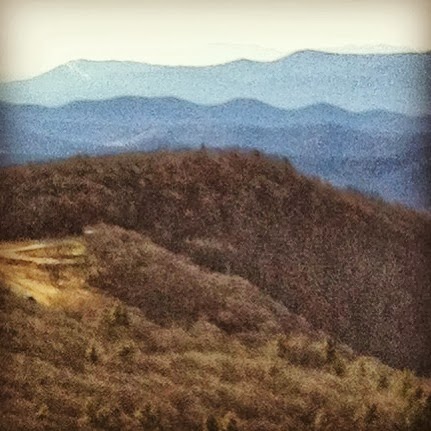
At the Stonyman summit.  Luray is just behind Mary
and me, and Lake Arrowhead is center right. The furthest
ridge is Great North Mountain, in WV.
It's probably just coincidence, but since we have been coming to Hawksbill Cabin, Mary and I have taken a couple of hikes in Shenandoah National Park on the last weekend in December or the first in January.  We continued that tradition with a short hike to the Stonyman summit last Saturday.

It was a great day for a hike, with clear, bright skies and warm temperatures, so the time was right.  But as the title of this post suggests, I had a couple of other ideas about the hike - for one thing, I wanted to try out my new Casio Pathfinder watch.  The other motive will be the topic of my next post.

The Stonyman hike is short, only 1.5 miles, and the elevation change is about 330 feet.  It qualifies as an easy one in my book - but it does end with one of the best views of Luray and the Page Valley that you will find in the Park.  Stoneyman is the second highest peak in the Park, by the way, at 4,010 feet - and on a clear day like Saturday you can see all the way to West Virginia.

The white blaze marks the route of the Appalachian Trail,
while blue blazes mark other routes throughout SNP.
Despite its shortness, this is one of my favorite hikes in the park.  It is close to the Skyland resort, so it was designed as an interpretive trail - there's a guide and marked stops to curate the walk in the woods - and there is a horse trail near the summit that marks a second vista that is often less crowded than the main observation point.

When I first found the trail, one of fondest discoveries was the twin blazes that mark the route: white for the Appalachian Trail, and blue for other hikes in the Park.  There used to be a sign where the routes diverged, about halfway up; I think that it said that point was the highest spot on the AT within the Park boundaries.  I need to go back and look through some past posts to remind myself, I know I have posted a photo of that old sign.

View to the Southwest, across Skyland Resort.
The peak in the upper left is where Massanutten Ski
Resort is, and you can just see the trails.
Using the new Pathfinder, Mary indulged me while I took measurements at three spots on the trail:  at the trailhead, at the point where the AT splits away, and at the summit.  Some features have changed since I had my last watch, but from experience I knew to take a reference altitude from a marked location, in this case the summit, at 4,010 feet, to calculate the climb.  I calculated a net gain of 326 feet, and for now that will be the high point record with the watch.

While we were at the summit I told Mary about the first time I took this hike, back in the days when I was checking off all the "Easy Day Hikes" routes (obligatory Amazon link below).  I got the horse trail summit and sat down to enjoy the view when my cell phone rang.  I spent 30 minutes on a work conference call up there that day, even though I was on vacation - you can bet I billed for that call!

The trail wasn't crowded, but we weren't the only ones who had the idea to go out on a hike. We enjoyed meeting a young family, a mother and daughter out on a walk, and then a couple from New Jersey (Red Bank - exit 109).  But as I mentioned, there was one other purpose for getting out on this hike, and I will post about that next.


By the way, here's the link to the Best Easy Day Hikes book I mentioned above:
Best Easy Day Hikes Shenandoah National Park, 4th (Best Easy Day Hikes Series)
It's not my only guide to the park, but I do refer to it frequently.


Friday, September 6, 2013

South River Falls: An Easy SNP Day Hike


Seems like I haven’t been up in the Shenandoah National Park much this year, so on Sunday I decided to take Tessie and head up for a little hike.  I hoped it would turn out better than the last one – we got rained on, and she had the most pitiful look ever in the car after.  We took a little drive to Elkton and took the short drive north to the South River Falls trailhead.

Heatwole describes this hike as 2.6 miles roundtrip, total climb of 850 feet, and about 2:15 in duration – that’s all pretty accurate in my book.  The hike qualifies as a moderately easy one by his rating, and by mine, because I like to see 5.0 miles and 500 feet before I consider a hike moderate. 

Along with not getting to the park as much this year, my exercise has tapered off too.  Where I used to walk Tessie a mile a day and then added 1.5 miles of walking back and forth to the subway, I’m down to the dog walk and maybe ½ mile of walking back and forth to a shopping center for lunch.  With the entire climb facing us on the return trip to the car, both the dog and I suffered on the second half of this one.

We took in some nice forest views on the way down, and I made a video of Tessie as she experienced crossing a stream that was hidden away under some rocks.  I’ll upload that at another time.  The outward leg of the hike ended at the little overlook with a view of the falls.

While Tessie and I took a break there, I was remembering that Chris and I did an extended version of this hike a few times when we were preparing for the Half Dome hike in 2005.  That route goes all the way to the base of the falls, and Heatwole has it as 4.7 miles with a climb of about 1,315 feet – so it still wouldn’t qualify as moderate by the standards I use today, but it was an effective early hike for us as we undertook the preparations for Half Dome.


I think the dog had a good time, despite our struggles on the return, and the time outside certainly inspired me to want to get back to the park more often this year.  I even bought a new annual pass, good until next September!

Monday, June 17, 2013

Hawksbill Mountain Day Hike

Looking south from the Hawksbill Summit.
It’s something of a ritual, whether it occurs in the spring, summer, or fall – but Mary and I find our way to the summit of Hawksbill Mountain in Shenandoah National Park at least once a year.   Most recently, that was during our vacation in late May. 

Lately, another part of the ritual for me is a stop at the Pinnacles overlook, where you can get a nice view of Old Rag, site of one of the most popular hikes in the park – for more on that, check out Bob Look’s blog in the blog roll on the right.  He’s a volunteer steward on the mountain, and is a source of a wealth of information about the trails, the wild life, and other goings on up on Old Rag.
Old Rag, from the Pinnacles Overlook.

We chose the route from the Upper Hawksbill Parking, at mile 46.7.  My Heatwole guide describes the hike: “Round trip 2.1 miles, total climb about 520 feet…A fairly easy hike on a graded trail and a fire road.  Good views from the summit.”
Page Valley below, from Hawksbill Summit.

I’m sharing a few photos from the summit with this post – the views are one of the reasons we go there so often.  But sometimes we go for the breeze, especially during the summer, because Hawksbill is highest peak in the park and it’s usually a few degrees cooler up there.

This hike will take you anywhere from 2 to 3 hours, depending on how much time you spend at the summit enjoying the 360-degree views or watching the hawks and buzzards gliding by.  There are often deer along the path, and there are always chipmunks and squirrels scavenging away in the underbrush just out of site. 


Since we can see Hawksbill Mountain from the cabin during the winter, I guess you could call this easy day hike a favorite.

Tuesday, May 8, 2012

Turk Mountain: An Easy SNP Day Hike


At the summit of Turk Mountain

As I mentioned yesterday, I took Tessie out for an inaugural hike in Shenandoah National Park recently, and chose the easy Turk Mountain summit hike as our destination.  Earlier we’d warmed up a little on Calf Mountain after entering the Park from Waynesboro, and afterwards we drove a few miles north on Skyline Drive to the trailhead for the summit.

There is a more challenging Turk Mountain hike described on Hiking Upward, and linked below.  They list their version as a 10.4 mile loop with multiple stream crossings and 2,400+ feet of altitude gain.  That’s not the hike Tessie and I took – ours started at the Turk Gap parking area, milepost 94.1, and we did a 2.2 mile out-and-back with only about 480 feet of altitude gain, net.

This is a well-maintained trail that runs along the AT for part of the way.  In fact, Tessie and I encountered a pair of north bound AT section hikers taking a lunch break at the parking area.  What a wet day it was – I’m sure that was keeping that appetite up, but I didn’t have any trail magic to share with them.

Rhodies
As you can see from the sparseness of my photography on this trail, I was pretty focused on working with Tessie on her leash for the route.  Still, we did enjoy the rhododendrons in bloom, and made note of several geologic layers that the trail passes through, including a couple of talus fields.  The rainy day really brought out the colors of the lichen that covered many of these stones.

Talus field
Upon reaching the summit, given the rainy day and overcast skies, there is not a lot I can report about the views that are supposed to be the highlight of this hike.  I’m one who doesn’t mind not having the view if the effect of the weather is interesting enough, and here it was, with wispy clouds blowing through the tree branches. 

This stony ridge is narrow and tough for footing, and my little dog looked up at me for guidance in some of the areas up there.   We had a good bonding experience – I’ll take her back on the trail sometime soon, and hopefully will be able to join my friends at Appalachian Outdoors Adventures with their dogs by the end of the year.

As far as the trail goes, this one offers a very typical experience for Park visitors.  It is a good one down in the Southern District, where there aren’t typically many crowds on the trails, so it has that going for it.  A hiker who has done the research on the vegetation, wildlife, and history of the Park will certainly find a lot here; and if you take the time to dig into the geology of the Park there is a lot to ponder in the nearly 500 feet of elevation gain here – you probably cover two or three hundred million years of geological history.

It’s one I definitely will do again, and I may even take up this route from Hiking Upward:

Tuesday, January 17, 2012

Snead Farm: An Easy SNP Day Hike


There are a couple of forks in the road -
mind the guide posts!

The old Snead Farm barn.


A few years ago, when I was making my way through the easy day hikes in the previous edition of the book I reviewed yesterday, I stopped by Snead Farm on a late spring morning with the intention of knocking this 1.4 mile out-and-back hike along a fire road, with an easy climb. The book also describes a longer, 3.2 mile loop - I've never done that one. 


Exterior of the root cellar.

By the time of year I visited - mid May, if I remember correctly, parts of the homestead were already overgrown with waste-high grass and I imagined I could actually see the ticks in there waiting for me, so I postponed a close inspection of the ruins here for another day.  I planned to come back during the winter, and I hoped I'd be able to talk Mary into it.  So it happened that over the Christmas holiday we went out and did this hike, pairing it with the Lands Run Falls hike I reviewed last week - as it happens, that is the same way I did these two hikes the first time.

Root cellar interior.


The story goes that this 200-acre apple farm was acquired by the park in 1962.  But unlike with many of the old farmsteads, the barn was not razed and you can see it when you visit, although you cannot get in.  There's also an old root cellar; which for me conjures up a vision of onions, carrots, turnips and the like - and a healthy share of winter squash to boot.


Bunkhouse foundation wall.

The tall grass had kept me away from the foundation of the old bunkhouse, but we were able to get a closer look at it during December.  In addition to the old concrete footers, there's an old cistern, and a couple of stairs where the old doorways were.  There's a substantial foundation where an interior stairway once stood, as well, so I assume the bunkhouse was a two-story structure.


Bunkhouse cistern.

On the way in, there are piles of stones, hinting at old pasture walls, and a couple of little springs that you pass.  It's a very pleasant and easy adventure, one I don't mind revisiting now and again.


Bunkhouse doorway steps, with the
old staircase in the background.

Monday, January 16, 2012

Book Review: Best Easy Day Hikes Shenandoah National Park

I took a look at the Amazon page for the Easy Day Hikes book I use for some of my hikes - there wasn't a review.  So I edited an old post into one and posted it there.  It's reproduced in full below - also included is a link to the Amazon page for the book.  Enjoy - and if you happen to visit that page, go ahead and check that my review was helpful if you found it was...
---
While planning a Shenandoah National Park day hike recently I found the new edition of a favorite guidebook, "Best Easy Day Hikes Shenandoah National Park," by Bert and Jane Gildart, which was published in 2011. This is the 4th edition. Since buying a country home in Luray, near the Park's headquarters, I had used the 3rd edition as a guide and hiked each of the 26 routes to familiarize myself with the park. I also kept copies of the little book in Luray and at home in the DC area.


On first review of the new edition, the major difference is the inclusion of 27 hikes, one more than were in the old edition. One of the old hikes was replaced, so there are two new routes in the book. A district by district comparison reveals that there are now 6 hikes in the North District, where there were five; there are 15 in the Central District, the same as before; and there are 6 in the South District, the same number as were in the 3rd edition.

The additional hike in the North District is Fort Windham Rocks, a 0.8 mile out-and-back without much climbing. In the Central District, a second route to the peak at Mary's Rock has been added: "Mary's Rock South," a shorter 2.6 mile out-and-back with less elevation gain than the traditional "Mary's Rock North" route. The entry that combined Betty's Rock and Crescent Rock was deleted from the Central District, and the South District list remains the same.

Shenandoah National Park used to be covered by farms. Nature's inevitable reclamation is one of the features of the Park experience, so the trails change. The Gildarts acknowledge this sometimes with a note that an old viewpoint might now be obscured by a new forest, or they mention unusual flora or fauna that has re-established itself, offering the visitor a chance at discovery in addition to the wonderful views from Skyline Drive.

One section that I enjoy referring to is the list that ranks the hikes from easiest to most challenging. I have my favorites on this list, and at the same time, if the choice were mine, there are a few I might exchange for others - I'm sure I'm not alone in this among those who know the Park well. Despite that exception, this guide has always proven useful to me when I am planning adventures in the Park, and I'm very happy to see that it has been updated.

Whether you are looking to experience an interpretive nature trail, to visit a waterfall or vista, or to check out some of the places where "the mountain people" used to live, you'll find this book a good place to start. It's a handy guidebook well worth the price. For myself, I'm looking forward to checking off the new routes that were added in the 4th edition.

---

Friday, January 13, 2012

Lands Run Falls: An Easy SNP Day Hike

During the holidays, I talked Mary into getting out on two of the Easy Day Hikes.  We actually did them one after another; Lands Run Falls was the second one of the day.  I'll post on the other, Snead Farm, on Monday.

I found Lands Run Falls in the Best Easy Day Hikes (Amazon link below) book.  It truly qualifies as an easy hike because it is only 1.2 miles round trip, descends about 300 feet total (remember, you'll be climbing on the way back), and it follows a paved fire road for some of the way before it transitions into packed gravel.

Most of the route is through a mature forest with oaks and hickories - the book says that there was some significant damage to the woods here during a tropical storm in 1996, but you'd be hard pressed to notice during the summer when the leaves are up.  There is also a lot of greenstone, one of the Park's ubiquitous igneous rock types, along the way.

The two photos are of the falls themselves, which you really can't get down to - they're observed from a safe spot at the top of the cascade, and it's really not advisable to climb down into the gorge.  I also took a photo of the upstream view of the stream, which spills over little cascades on its way down to the plunge.  To get to the falls, you walk to the spot where the stream crosses under the fire road, and take a little spru trail on the right about a 100 yards. 

There are a couple of twists and turns in the route as you approach the falls, and I've found that disorienting before, since it makes the route seem longer than it really is.  But you start hearing the falls from about a quarter mile away, which reassures that you are approaching your goal.

The book calls it "a nice leg stretcher"...I agree.

Thursday, December 1, 2011

Best Easy Day Hikes Shenandoah - New Edition

When I posted about our little day hike to Bear Fence Mountain last weekend, among the things I noticed while writing was that the new edition of "Best Easy Day Hikes Shenandoah National Park" has been published.  This book, compiled and written by Bert and Jane Gildart, is the 4th edition, and was published earlier this year.  It updates the 3rd edition that was published in 2006; I have an Amazon link at the end of the post if you'd like to check it out.

When Mary and I bought Hawksbill Cabin in 2007, I figured that since Shenandoah National Park was so close - Hawksbill Mountain looms over the drive into our place, nearby Hawksbill Creek draws its source from a spring near Big Meadows, and we can see Tanners Ridge from our brick terrace - that I should make a point of getting to know the Park best I could.  I used the 3rd edition as a guide, setting a goal to complete all of the hikes in the book, an objective I fulfilled in 2010. 

On first review the major difference is the inclusion of 27 hikes in the 4th edition, as opposed to 26 in the 3rd.  Not only are there additional hikes, but some of the old ones have been deleted or replaced.  A district by district review shows that there are now 6 hikes in the North District, where there were five; there are 15 in the Central District, the same as before; and there are 6 in the South District, the same number as were in the 3rd edition.

The additional hike in the North District is Fort Windham Rocks, a 0.8 mile out-and-back with negligible elevation gain.  In the Central District, a second route to the peak at Mary's Rock has been added: "Mary's Rock  South," a 2.6 mile out-and-back that is shorter and has less elevation gain than the traditional "Mary's Rock North" route.  The entry for Betty's Rock and Crescent Rock has been deleted from the Central District list.  The South District list remains the same.

Generally, I'll be interested to get into the individual hike reviews in more detail to check out the updates.  Our Park is dynamic in that it used to be settled and covered by farms; while the establishment of the Park retains some controversy in the surrounding areas, the inevitable progress of nature's reclamation is one of the features of the experience, and that means that the trails are constantly changing.  Where there was a view in the past, there may be a new forest obscuring it now, for example...or some unusual flora or fauna may have re-established itself somewhere, causing the visitor to focus more on the micro-landscape as opposed to the wonderful views from Skyline Drive.

I have my favorites on this list, and at the same time, if the choice were mine, there are a few I would leave off.  But this guide has been very useful to me during my adventures in the Park, and generally I'm very happy to see that it has been updated.  Once I found out it had finally been published I couldn't wait to get a copy for myself.

Amazon link:

Tuesday, November 29, 2011

Bear Fence Mountain: An Easy SNP Day Hike

It being Thanksgiving weekend and all, Mary thought it might be fun to take a little walk in the Park.  Since she had never been before, I suggested we might go over to Bear Fence Mountain and explore it a bit. 

This relatively short trail - the Easy Day Hikes book (Amazon link at the end of the post) has it as a 1.2 mile loop with less than 400 feet of elevation gain, showcases the essential geologic history of the Blue Ridge.  The central portion of the hike, and its highlight, is a rock scramble along the ridge pictured here that is about a third of a mile in length. The mountain's summit is about 3,470 feet above sea level.

The trail to the scramble passes through the Park's signature greenstone and sandstone formations, and transitions to Catoctin basalt at the scramble itself. I prefer to take the loop trail for the opportunity it provides to have a good look at the stony layer from below, and then from being up close and personal during the scramble.

Funny thing along the way - after the initial photo above, my iPhone told me it was out of memory and it wouldn't allow any more photos.  I'll get that checked out, but in the meantime we fell back on Mary's good old fashioned RAZR, which is what I used to use for the blog.  These small format photos are taken with that camera.

This absolutely stunning view looking north towards Tanners Ridge and New Market gap was taken from a view point on the AT a couple of hundred yards south of the scramble. 

Full disclosure:  Mary and I didn't do the full rock scramble.  This trail is one of the better visited ones in the Park - there is even a Ranger Program that comes here (one I'd like to join sometime), so there is a lot of traffic on the mountain.  While the challenges of this scramble don't compare to Old Rag due to its length and the lack of significant elevation change, it does give a good preview of the experience you can expect on that landmark, and the transitions through the geologic layers are the same as what you'll see there.

Here are a couple of mountain portraits of your faithful blogger and his loving wife.


 And here is the Amazon link to the Easy Day Hikes book, if you are interested (hey!  Fourth Edition!)