Ramble On

Tuesday, May 31, 2011

Wild, Wild Life

This week I will be posting a review of the Piney Branch-Piney Bridge hike that Chris, Tom and I did on Sunday. For now, I will leave it as having been a pretty rigorous trail, for several reasons – including the heat, which was in the ‘90’s. Today, a short post on the wildlife we saw…there was, indeed, plenty to behold both in rumors of encounters and in actual encounters.

It all began with our rendezvous in the Elk Wallow wayside’s parking lot. There was a lady standing next to her car waving her cigarette, talking to Chris, telling him that a deer had been hit on the drive nearby. That might not be an infrequent event – I’ve had some close calls in the dusk hours myself up there - but the tale just got taller.

She said that “those kids over there” said they’d seen a bear, which evidently had caught scent of the blood and started nosing around the area of the accident. I looked over to where the kids were – there were two ranger vehicles with them; I decided this part was made up, although I will give the lady credit, she was just repeating something she thought she’d heard. See, locking down two rangers in a wayside parking lot with a bear on the loose - on the hunt, even - on one of the busiest visitor weekends of the year just didn’t make sense.

Chris and Tom got busy outfitting themselves and I continued to observe the events going on around us. “Those kids” the lady mentioned were hanging around a mini-van with Ohio plates. The radiator grill was all busted apart with a few pieces just barely hanging on. The owner, maybe those kids’ dad, was reaching around under the hood…my guess, trying to get the thing road-worthy again after a deer strike.

Finally the rangers finished up their business over there and drove away. I quickly moved on to breakfast, as by now, the wayside grill was open and I went in for a tasty breakfast sammich; meanwhile, Chris, at least, was finally outfitted and he went over to the men’s room.

While he was there, he heard the mini-van owner talking to the kids. “Now you kids – how many times have I told you all how to behave in front of the cops?” he said. “We got enough on our heads without you kids bringing more trouble. There’s going to be a whuppin’ later on after all this is finished up!”

After 20 minutes and one breakfast sammich later, we were at the trailhead trying to make sense of that scene for a few minutes. Well, just some hard luck with a family on a little recreational weekend, we decided, and we were underway.

Getting to the real wildlife that we encountered, a large toad was the first animal we saw. That was unusual for me in the Park. I’ve run into lots of other creatures but never a toad, and this was a good sized one. There were plenty of insects around, so he was probably pretty contented on that stretch of path.

The ribbon snake in the photo that accompanies this post was the next animal. You know, snakes aren’t the most popular animal in the forest because they are so sneaky. You’re not looking for them, and suddenly there they are, popping up in just the place you want to sit down to have lunch.

So in a sense, running into a ribbon snake was a lucky encounter, rather than an unlucky one. They’re not venomous; and at an average of two feet long – as this one was – they’re not very threatening. So we kept an eye on it over there, maybe two yards away, while we took a lunch break.

Eventually it slithered on away. My book on snakes (Amazon link below) says the ribbon snake likes the environment we were in there at that spot, near a stream, in the cool shade of a forest. I’d make a note that as far as I can tell, no snake native to these United States that is striped lengthwise is venomous. So if you encounter a snake with that coloring, try to enjoy the encounter rather than run terrified and screaming away.

We also ran into one of my favorites, a ring-neck snake. Here is a link to a photo of one that I found next to the pool: http://hawksbillcabin.blogspot.com/2008/08/battle-of-species-snakes-in-pool.html. These little guys – the size ranges up to 18 inches long, although the ones I have seen have only been six inches or so – are hunters, like many reptiles, if you can believe that. Their meals are mostly bugs, so they’re another friend in the forest.

When we finished the hike, we were de-accessioning our gear at the trailhead and a ranger drove by. He stopped to chat about conditions on the trail, making sure everything was okay with us and other hikers. We were superior, but tired.

But since he was chatty, I did ask him about the bear story. He said his shift had begun at noon (the bear situation would have been before 8am, I’m guessing), but if something like that had happened he would have heard. So it was just a tall tale, although the ranger did say, “Oh yeah, there have been plenty of bears about lately!”

We decided to head out of the Park by way of Elk Wallow again. It was crowded, but as we parked, I saw the derelict mini-van sitting there, probably waiting for parts, or for a tow. No sign of those kids or their carefully law-abiding dad. Then we were on our way.

Our wildlife encounters weren’t quite done, though. Heading south to the Thornton Gap entrance, there was a turkey hen sitting near the road, stopping traffic. And after we left the park, there was a snapping turtle crossing 211 coming up from pass run. Some nice local guy had stopped to help her get across - I hope he wasn’t bitten, although the females seem to be pretty docile at egg-laying time, really focused on getting about their business.

Friday, May 27, 2011

Clarendon Construction - May 2011

So, a quick update on the progress of the new building going up between the two original elements of Clarendon Church.  Although I have to admit that this is a very interesting adaptation of the original building, I remain cynical of the motivations of everyone involved.  There is only one explanation for this hideous building - developer greed, supplemented by an equally greedy congregation at the old church.

Don't try and convince me that we were motivated by social good when we reserved some of the new apartments for mixed income.  That was so that we could maximize how many units are for sale at market rates.

Now, I do have two photos to post today - since my office relocated inside the current building to the 7th floor with no view of the construction, I'm taking ground level photos these days.  As you can see in the first image, the construction of the floors have topped out, and the concrete has cured enough to begin framing out the walls on the lower floors. 

During this stage of the effort, it's quite colorful with the moisture barriers and other materials going up. I snapped the second photo as I was driving out of my garage on the way home last night.

Thursday, May 26, 2011

"Quiet Please"


I was going through some old notes and I found materials I put together to document the playlist from the Nick Lowe show Mary and I went to last November (the original review post is here: http://hawksbillcabin.blogspot.com/2010/10/its-okay-to-like-nick-lowe.html). Last night as I was grilling dinner I put on “Quiet Please…the New Best of Nick Lowe,” and got a pleasant reminder of the show, since many of the songs he performed there are included – not to mention the bonus DVD which includes a live performance in Belgium, and several of the original videos.


One of my favorites of Nick’s recent work is the song “I Trained Her to Love Me,” which was off the “At My Age” album. In the liner notes to Quiet Please, the song is introduced as follows:

“…Sure, it contains some seemingly effortless, highly coverable tunes, but it pivots on ‘I Trained Her to Love Me,’ a masterpiece with the power to shock the unsuspecting listener. Go to any Lowe concert and watch the uninitiated recoil in disbelief as its cutting lines are unleashed.”

Phew. Even the initiated can be startled by this one. So I did a little Google search and found a blog post (linked at the end of this one) where the writer transcribed the lyrics, they’re reposted below. Enjoy!


I Trained Her To Love Me

Do you see the way she lights up
When I walk in the room
That's good

And the skip in her step
When we're both out walking in the neighborhood
This one's almost done
Now to watch her fall apart

I trained her to love me
So I could go ahead and break her heart

If you think it's depraved
And I should be ashamed
So what

I'm only paying back womankind
For all the grief I got
I've got the latest believing
Forever I'll be true

I trained her to love
Now excuse me, I've got work to do

I trained her to love me
And I'm gonna start working on another after this
And when I get that one in a state of bliss
Betray her, with a kiss

Well one time, one cut-up rough
told me I only do this cause I can
And I'm bound to wind up one lonely twisted old man

But look out,
Here comes a prime contender
for my agenda
If ever there was one
And I'm gonna train her to love me
Until it's time to do what must be done
Train her to love me

And I'm gonna start working on another after this
And when I get that one in a state of bliss
Betray with her a kiss

And I'm gonna start working on another after this
And when I get that one in a state of bliss
Betray with her a kiss
I trained her to love me

To late to stop now

Lyrics transcription from http://immodestproposals.blogspot.com/2007/06/saturday-whatever-lyrics-nick-lowe-i.html.

Wednesday, May 25, 2011

The Remodel that Goes on and on

Quickly on the heels of our kitchen remodel, Mary decided to take on the master bath and make some improvements that she had planned for a very long time.  New tile, reglaze the clawfoot tub (from '80's pink to original white), and new wainscot paneling, among other things.  She added a small project to build in knee-wall closets make it more attractive to the contractor.  We thought that if we jumped into this right at the end of the kitchen it would be done quickly.

Easy peasy lemon squeezy.

No such luck.  Here we are entering the third month...only a little progress to show each day.  My hypothesis is this job is too small and the contractor is mixing it in with some other small jobs.  At this point the project has nearly taken as long as the kitchen.

Anyhow, here are some photos...the new tile, in the old style; the clawfoot tub (note the stained glass windows we are retaining), a look at the new paneling, and finally, the kneewall closet in progress.  It is cedar lined with heart o' pine floors, like the rest of the upstairs (downstairs is oak).

Hope to be done with this next month.

Tuesday, May 24, 2011

Get your mind dirty


With the increasing travel schedule and other work pressures, I’ve been slower than usual to post so far this year. I’m not writing today to lament that – I appreciate those readers who’ve found the blog on their own or who read on FB – thanks very much! Just an observation, and since I am writing today from the brick terrace watching the dude do his job in the pool (almost finished!), I wanted to switch gears a minute for this post.


On my trip to Barstow a few weeks ago I picked up the June 2011 edition of Outside magazine to read in flight. As usual there are plenty of good articles, but this time a column by Richard Louv caught my attention with the headline “Get Your Mind Dirty.” Louv has a couple of books to his credit, including 2005’s “Last Child in the Woods,” and “The Nature Principle” just published (the image here includes an Amazon link).

Now, Louv argues something that seems to make a lot of sense – “the more high-tech our lives become, the more nature we need.” And the clarion call is the fact that more than half of the world’s population lives in cities for the first time in human history. He writes:

“While the study of the relationship between mental acuity, creativity, and time spent outdoors is still a frontier for science, new data suggests that exposure to the living world can even enhance intelligence. At least two factors are involved: fist, our senses and sensibilities can be improved by spending time in nature; second, the natural environment seems to stimulate our ability to pay attention, think clearly, and be more creative.”

There’s quite a bit more in the column in this month’s Outside, and I think I will pick up a copy of the new book for our upcoming vacation to Cape Cod. But in the meantime, I have some experiments in mind, starting with my 75@75 project – next hike is this coming weekend. Those hikes are designed to be challenging across the full range of their details, and the early ones that take advantage of long summer days are especially so.

Monday, May 23, 2011

Thru-hikers on the AT, and at AOA

There was a recent FB post by Gary over at Appalachian Outdoors Adventures about Appalachian Trail (AT) thru-hikers; apparently he had a couple of folks in the store and they were enjoying their break in town with a stop at the store. I’ve seen a couple of hikers out on some AT sections already this year – about this time is the beginning of the peak for this part of Virginia, so I wanted to make a point of taking a look at the AT log that they keep in the store.


Now, for those who aren’t familiar with the AT, here are a few fun facts: The trail runs approximately 2,165 miles (the figure is constantly revised, as the route changes slightly from year to year for various reasons) through 14 eastern states, from Springer Mountain in Georgia to Mount Katahdin in Maine. It is estimated that between 1,500 and 2,000 people attempt to thru-hike every year, and as many as 25 percent may complete the journey, but most estimates put the number at around 20 percent. There have been as many as 5,000 hikers who have completed the AT thru-hike.

I compiled that information from various sources, there is general information at the Wikipedia link below. There are a number of good books on the topic of thru-hiking, including “AWOL on the Appalachian Trail” and “A Walk in the Woods” – I may add Amazon links sometime in the future.
Sunday afternoon Tessie dog and I were making our rounds, and we made a stop at the store. Linda showed me the log and told me that it seemed like they’d already had a lot of people in this year. I made a count and found 26 so far – they may have had some that didn’t sign in, or just didn’t record the visit for whatever reason.


-


The first “north bound,” or no-bo, hiker this year was “Trail Blazer” – he was at AOA on April 4. I assume he’d gotten an early start, and that he was trucking through the miles. In any case, he certainly picked an appropriate trail handle.

The log book showed that a south bound (so-bo) hiker was in on March 14, but I couldn’t make out from the entry if this was a thru-hiker or not. It was hard to figure out, since at the normal pace that hiker would have started in November or December, and I don’t think you could get through the Maine and New Hampshire sections at that time of year. So I didn’t count that entry in the total.

There were quite a few interesting posts in the book and I enjoyed reading them. There was an entry from a hiker that had left a fleece jacket along the Trail back in April – with cold days (the estimated annual “frost fee” date in Luray is May 14 (thanks, David Sours), and we are at least 1,000 feet below the trail as it winds through Shenandoah National Park) still ahead that is a needed item – who offered a reward and a description.

On Saturday this week, a couple of my Northern Virginia friends were in the store to pick up some supplies for a camping trip they were in over at GWNF. They reported running into two thru-hikers in the store during their visit. Maybe they were the very same thru-hikers who recorded being in town for “a couple of zeroes” – zeroes being zero trail mile days – and a movie, along with a hockey game down the street at Uncle Bucks.

http://en.wikipedia.org/wiki/Appalachian_Trail

Friday, May 20, 2011

The Pool Chores Begin: 2011

The pool chores begin with "the dude" at work.
A few weeks back, I mentioned that Uncle D's was out to open the pool.  They take care of the biggest part of the job for us, but whenever that winter cover comes off, there is always the fine detritus left on the bottom of the pool.

For this, we use a combination of old fashioned manual labor and the hardworking pool robot - "the dude."  So last Sunday it was a happy time to go into the garage and break him out to start his summer job.  After a few maintenance chores - a field mouse had built a winter nest in the housing, I plugged him in and put him to work.

My part of this was to take the pool brush and scrub down the concrete surfaces next to the pool - they're going to need some new paint this year - and then the part of the liner that is above the water, followed by scrubbing down the walls under water.  I also clean out the little baskets in the filter returns, which were full of oak tassels and little pine cones.  I've got some in progress photos here to accompany the post.

In progress, with the debris swept up.
At the end of the first pass.  A few more hours of man-machine efforts and we'll be good to go.
This is a series of tasks that I take care of over two weekends; this year we're getting an early start and we should have the pool ready for Memorial Day weekend.  That's a good thing, since the next 75@75 hike will be then, and it is going to be a rigorous one, since we'll have a lot of daylight.

Thursday, May 19, 2011

For Marilyn x4

Here's to my friend Marilyn and her dad:


"four times in a row"

Wednesday, May 18, 2011

Motoring West - Final

One of the fondest images I remember from my first drive to Los Angeles, back in 1996 when I headed out for graduate school at USC, was this descent from the high desert on I-15 as you enter the LA Basin. 
When you hit this spot, you've been screaming through the desert at high speed from Las Vegas (although we were coming from Barstow this time), with gentle climbs and descents up in the range of 4,000 feet of elevation.  That desert is hot - my radiator had given out in Utah and Nevada and I'd had the core replaced in Las Vegas (AAA recommended a garage on the strip - right next to Caesar's where the Bellagio fountain is these days) - so all I could think of was, "am I going to see the little red light again?"  And you've been driving bumper to bumper at 80 miles per hour for more than 200 miles by that time, passing scorched pavement from car fires every couple of hundred yards with burned out hulks pushed aside into the median.  A surreal place. 

Then suddenly, you round the bend, and those green mountains that catch the last drops of Pacific moisture and that have been growing on the horizon hit you in the face like a wall, and you begin a sharp descent of a couple thousand feet through a five mile long pass.  It's pretty exhilarating, and for east coasters, like me, even disorienting. 

In the photo, we are headed southwest to the Ontario airport.  You can see the oncoming east bound traffic under the guardrail on the left side of the photo, and you can see the road ahead to the right.  There's even a light touch of snow left on one of the peaks over to the right, as it had rained Monday night in the lowlands.

Tuesday, May 17, 2011

More from the West

A few more photos from my trip last week.

Here is a view of the Salton Sea (from my exit row aisle seat, there were no passengers between me and the window - exceptionally rare these days!).  I had seen it on the way in, and was ready in case I saw it again on the way out.

The story of this inland sea is very interesting - there is quite a bit of folk lore about it; here is the Wikipedia article if you are interested: http://en.wikipedia.org/wiki/Salton_sea.  Basically, the current version of the sea was formed due to a combination of engineering accidents and wet weather in 1905, although the sea bed here is prehistoric.

Another of the interesting sites was this sign at the intersection of I-40 and I-15, just east of Barstow proper.  This is actually milepoint zero of I-40, and the sign indicates the distance to the terminal point of the highway.

After the experience of riding a short distance on nearby Route 66, my guess is that I-40 is the highway that forms part of the setting for the back story in the Pixar movie Cars.  You definitely get that feeling of moving with the land on that part of Route 66, while zooming by on Southern California freeways at speeds in excess of 80mph only gives you a sense that you are passing everything by.

The last photo for the day is from the little excursion I had to make down to Ontario on the third day of the trip - due to logistics, a couple of the team members flew out on Wednesday night.  After we got into town, we found a drive through In-and-Out - it was truly a drive through; there were only four outside tables and they were full.  So we ate using the hood of the car as our table.

If you are interested in some follow-up here, the chain made a cameo in The Big Lebowski...here's a clip.  Mind the f-bombs!

 http://youtu.be/L9xvmpRZcyw

Those are good burgers!

Monday, May 16, 2011

Motoring West

Last week I was on another of those business trips that have been keeping me busy this year - this time to Barstow, CA.  Now, Barstow is a small town, about halfway between LA and Las Vegas.  The Marines base there is one of the largest employers, if not the largest, and that was my destination.

I usually make a plan to take in some cultural aspect of these destinations...in this case, I only had the song "Route 66" as a point of reference, so I had resolved I would find a stretch of it somewhere and take a short drive.

Now, I had driven through the Barstow area once on the way to USC for graduate school, but to be honest that was a long trip with the destination within sight at last, so I didn't remember anything about passing through there - except a vague impression of the high desert.  I hope to have an image from one of my colleagues later in the week that I can share the one lasting impression of the drive through the first time.

Sure enough, the old highway was out to the east of the base - it also runs through downtown Barstow.  But there is a five mile stretch of it to the east.  It runs up and down small grades and arroyos, which turn out to be washes that feed into the Mojave River.  As Wikipedia notes (http://en.wikipedia.org/wiki/Mojave_River) this river flows mainly underground - the surface was certainly bone dry when I drove across it and took these two photos:


It was quite a thing of beauty to see.  I've heard tales of folks drilling wells near the river and finding the flow, which was quite strong.  And there was an anecdote on the base about some heavy rains that filled the streambed to a depth of seven feet - threatening to rise out of the banks even.  That is something that was honestly hard to imagine during my trip.

Wednesday, May 11, 2011

Chores in Red

A couple of weeks ago, my friend Marty mentioned that he'd had his first hummingbird siting of the year.  That started me thinking that we'd probably see some soon enough at Hawksbill Cabin - I still had the regular feeders up and needed to change over to hummingbird feeders.

I should note - the pool's been opened already (shout out to Uncle D's team!).  I've got some work to do down there before it is ready for swimming.  I hope to get to that next weekend.

So this weekend, as I sat enjoying my coffee on the brick terrace, wearing my red sandals, I was cheerfully greeted by a little ruby-throated hummingbird who came to check out his favorite red color, only to be disappointed that he'd found my shoes.  Or maybe that cheerful greeting was scolding...in any case, it was off to Tractor Supply for some syrup.

I was buzzed again before I got away, and then, to my surprise, I saw one of them checking out the empty seed feeder in the maple tree.  This is the same place I hang a hummingbird feeder every year - so I'm wondering if we get the same ones back every year.  I hear they are habitual creatures.

Now, when I get into Tractor Supply sometimes I can't help it and I buy something else.  Since we got the new fence I thought it might be a good idea to put some reflectors on that end post.  So I got some help to find them - they were not where I expected them and we had to cruise by the trailer hitches and light kits, but at last there they were.  I bought two, and now they are properly installed.

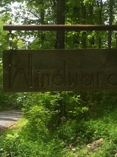
As I looked up from my task, I noticed the overlooked sign that is in front of the place.  Long ago, the Thompsons named the place Windward - they made a nice sign for it that the last owners replaced with this hand-chiseled one.  We've since found the old one, which we keep as an artifact in the shed.

Mary says she plans to paint in the letters soon.  Color:  Red.

Tuesday, May 10, 2011

Overall Run Falls: A Moderate SNP Day Hike

This is the second hike in my 75@75 project, which I outlined in yesterday's post.  Tom and I had been discussing our opportunities for hiking together a few weeks and finally settled on Saturday as the day for it; I wanted to be sure to notch some miles on the project and he patiently agreed to a hike in Shenandoah National Park. 

I proposed Overall Run Falls, a hike I'd heard about and had never done, which is described on the map you can get from the entry station as follows:

"6.5 miles round trip from [Matthews Arm Campground] ampitheater parking lot to a viewpoint of the 93' waterfall; moderately difficult.  Take the Traces Trail from ampitheater parking lot to Tuscarora Trail to Overall Run Trail." 

The ranger at the entry station advised us that the campground was not yet open for the season and that we would need to pick up the trailhead at Hogback Overlook.  This version of the hike is mentioned in the Heatwole Guide that I like to refer to - the trail is close enough to 6.5 miles despite the change of starting point that I am counting it as that many miles.  I calculated the net elevation as 1,333 feet based on my trusty Casio Pathfinder, which I would note had the high point of this hike at 1,010 meters, or 3,133 feet, compared to the elevation of the overlook, which is listed at 3,384 feet - that's pretty close, more accurate than most of the time.

This route included about  four tenths of a mile (or eight tenths counting the round trip) on the Appalachian Trail; as a matter of fact, the highest point of the hike was on the AT at a spot that looked like it could have passed for a through-hiker campsite, even though it was very close to Skyline Drive.  Maybe it would be a quiet spot at night when the motor cycles are shut down.

After the intersection of the AT to Tuscarora/Overall Run Trail, it's mostly a gentle descent with a few steep sections to the overlook of the falls.  There is a single stream crossing which would likely be dry in the summer, and you have other typical SNP scenery, like the big rock shown here.  There were still dogwoods in bloom during our hike and we caught their gleaming flowers off in the forest to either side of the trail; some mountain azaleas were just getting started at the lower elevations; and these little geraniums were charming next to the trail.

Finally, you begin to hear the falls - there are some small cascades away off from the trail as you approach the stream and then begin to parallel it for a short distance.  Then the first encounter is the 29' upper falls (the photo of Tom was taken from above the upper falls), and after continuing down for another hundred or so feet, you reach the overlook of the main falls (first photo, above), which is 93'- the highest in the Park.  That's where we stopped for a snack - enjoying the view down the hollow.

There was a couple who were working their way down to the stream, which you can do if you are adventurous.  But I had read ahead in Heatwole:

"From one of the viewpoints a blue-blazed trail descends to the base of the falls.  This trail is extremely rough going, hazardous in wet or icy weather, and infested with rattlesnakes.  Not worth the risk and effort."

Needless to say, if Heatwole says don't do it, that is good enough for me!

After we enjoyed the stop watching the falls, we turned and headed back uphill.  We took it easy, but the steep sections aren't many and we were pacing ourselves for the long haul.  When we got back to the parking lot, we found it had really filled up, and cars were parked on both sides of the Drive.  That made getting Tom's unnecessarily large vehicle (he's driving a new Highlander) a little tough to manuver out of there, but we made it safely.

Including the lunch stop and the gentle climbing, we did the hike in 5 hours - a little more than one mile per hour, so faster than our usual pace.  Heatwole estimates that 6 hours are required for this one, so we bettered that.  Entirely satisfactory.

Monday, May 9, 2011

About the "75@75" Project

Some of my regular hiking friends know this already, but I have made up a little project for myself as an observance of the 75th anniversary of Shenandoah National Park this year – the project is called “75@75,” and it involves hiking 75 miles in the Park this year, before the closings of the main facilities in November. I'll be documenting these hikes using the project name as a label.

Ideally, these hikes will be moderate or difficult, meaning (these are my own arbitrary definitions) that they are five miles or longer AND include a net elevation change of more than 500 feet – by net, I mean the elevation difference between the hike’s highest and lowest point is 500 feet, not counting PUDs (pointless ups and downs).

So far, between the Camp Hoover hike (7.5 miles and 1,500 feet) Chris and I did in April, which has already been reviewed here on the blog, and the Overall Run hike (6.5 miles and 1,300 feet) Tom and I did on Saturday - post to follow, I have approximately 14.0 miles towards my goal.

With almost 20% of my 75 mile goal already done, I took a few minutes on the brick terrace to outline the plan for completing the project.  Recognizing that this summer will be a busy time for my regular hiking group - especially for Chris and Tom, both are expecting, I'll go ahead and invite readers who might want to join me on the project to come along. 

So here you go, seven candidate hikes, plus a bonus hike, that would take my total miles to approximately 80 miles – a little extra in case of inaccuracies in the guide books.  They are listed by mile post and not in the order I want to do them, plus the eighth bonus hike if I'm having too much fun and time permits:

• Hike 1 - Bluff Trail/AT, mile post 17.6, distance 12.8 miles, altitude change 2,400. Includes two summits and some views, and about 5 miles on the AT.

• Hike 2 - Piney Branch/Piney Ridge, mile post 22.1, distance 8.3 miles, altitude change 1,700 feet. This one includes a mountain cemetery, old homesite, stream crossings, and a small waterfall.

• Hike 3 - Knob Mountain/Jeremy’s Run, mile post 24.1 (at the Elk Wallow Wayside), two versions either 11.7 or 14.0 miles, elevation from 2,600 to 2,800 feet. There’s a stream with cascades and a falls, and a summit.

• Hike 4 - Hazel Mountain, mile post 33.5, distance 5.3 miles and elevation change 1,070 feet (the easiest on this list!). No summit here, but it is interesting for a combination of a falls, cascade, and a small cave. Depending on when we go, maybe no spelunking – the snake scene in True Grit still creeps me out.

• Hike 5 - Pocosin Mission and South River Falls, mile post 59.5, distance 8.5 miles and elevation 1,800 feet. This combines the ruin of an old cabin and mission, and then takes in the South River Falls, which was one of Chris’s and my main training hikes for the Half Dome a few years ago.

• Hike 6 - Black Rock/Trayfoot Mountain Loop, mile post 84.8 or 87.4, distance approximately 10.0 miles and unestimated altitude change. This trail is shown on one of the Park’s maps, which include distances but not altitudes. This will take in the rock scramble at Black Rock, an old fire observation point on Trayfoot Mountain, and the hollow where the Black Rock Springs Hotel was located in the late 1800’s.

• Hike 7 - Riprap Hollow and Wildcat Ridge, mile post 90.0, 9.8 miles and 2,400 feet. Includes the two Civil War lookout points Chimney Rock and Cavalry Rock, 3 miles of AT section, cascades and a falls.

• Bonus Hike (8): Hannah Run and Hot-Short Mountain, mile post 35.1, 9.1 miles and 2,800 feet. This one includes ruins of mountaineer cabins (for Chris, it is near the Corbin Cabin area we did last year) and a stream.

I should note that I compiled this list from the Heatwole Guide, and his measured the total altitude change instead of the net approach I prefer…so keep that in mind.

My next hike on this series is scheduled for late May, and should be one of these, most likely one of the waterfall hikes, since they tend to dry up later in the summer.

Sunday, May 8, 2011

Green Tunnel - an Interesting View of an AT Thru-hike

Found this a few weeks ago and meant to post - it is a compressed video of a recent thru-hiker's record of his AT hike.


Green Tunnel from Kevin Gallagher on Vimeo.

Friday, May 6, 2011

Poultry Litter Advisory Group - Follow-ups Part 4

Today, for my fourth post number on the thread about comments provided to DEQ on the scope of work from the poultry litter working group, I have reviewed and will summarize the letter sent by the Southern Environmental Law Center and the Shenandoah Valley Network. This letter was dated April 25 and signed by Cale Jaffe and Kate Wofford; the version I have is a PDF, so I cannot cut and paste the entire document, thus the summary below.


The letter begins by acknowledging that the DEQ’s and DCR's efforts are meant to restore the Chesapeake Bay and this study is part of that, contributing by analyzing options to reduce net nutrient load from the Shenandoah Valley. The letter also “acknowledges and incorporates by reference” comments that were provided by other significant stakeholders, specifically, the Chesapeake Bay Foundation and the National Park Service.

The letter outlines three general concerns about the scope:

1. The focus on a single solution – a proposed 55MW litter to energy “incineration and power generation facility” – the draft scope of work says “The purpose of this work plan is to guide research to determine the net environmental benefit of a major litter to energy project. The letter goes on to compare that to a neutral focus considering “the net environmental impacts of a major litter to energy project.”

2. The “short shrift” given to a review of alternatives – the only alternative mentioned in the scope they reviewed was a subsidy for bulk transport of litter out of the Chesapeake Bay watershed. The alternatives that should be considered include on-farm technologies, smaller centralized incinerators, improved land application and management methods at the farm level, anaerobic digestion, gasification or thermal oxidation.

3. The draft scope ignores air quality and public health concerns. Here there is a reference to public and stakeholder comments at the 2/11/11 and 3/28/11 meetings which were focused on these potential impacts, yet the DEQ scope ignores them.

Additionally, the letter offers six further comments:

a. The scope of the study should consider air deposition of nutrient loads, since nitrogen compounds can be distributed this way and would likely make their way into the watershed;

b. The scope should include the use of an approved EPA modeling technique for the air deposition analysis by looking at three alternative potential sites and the impacts that result from local climate conditions at them;

c. The scope should provide an expanded description of how land application alternatives will be evaluated; there is a reference to the use of alternative commercial fertilizers “in correct agronomical rates” but appears to assume that there would be no net impact from them;

d. The scope needs to include an evaluation of the storage and transport stages is considered, those handling activities that occur prior to incineration, since there is the potential for watershed impacts here;

e. Since a litter-to-energy plant is not proposed as a replacement for any retired generator facilities, it is an additional source of pollution – there is no real benefit of reducing emissions from the impact of new technologies, only the impact of adding to them, given this situation; and

f. The scope should analyze the ability to meet other standards for poultry litter feedstock generating units.

The letter concludes with and encouragement to strive for the best possible study – as opposed to outright opposition to the plant.

For my fifth and final post on this short series, I hope to have a summary of the scope of work – this will be the draft version these recent posts were responding to – and I will try to have that up on the blog by Monday.

Thursday, May 5, 2011

Poultry Litter Advisory Group - Follow-ups Part 3

By way of post number three in the continuing on the thread about comments provided to DEQ on the scope of work from the poultry litter working group, here are excerpts from another stakeholder’s comments.


“…I thoroughly agree with the feedback that you are receiving from the National Parks, the Southern Environmental Law Center, the Shenandoah Valley Network and others regarding your focus exclusively on a 55-MW Fibrowatt incineration facility, and your decision that the study group should ignore air emissions. Your minutes from the comments made by both members of the Advisory Group and the public during the March 28th meeting indicate that "emissions" were mentioned 22 times either directly or indirectly (e.g. indirectly via the word "health"). If you continue to dismiss the thoughtful comments of the members of the Advisory Group and the public, you risk the appearance that a final decision has already been made, the Advisory Group's analysis will be ignored, and that the DEQ's decision will be in Fibrowatt's favor. I am sure that you want to avoid that impression, especially since a proposed scalable, NRCS best management practice (BMP) called animal waste gasification is a [low-emission], economically-viable alternative to incineration.

I am still trying to obtain a copy of the comments sent by the Southern Environmental Law Center and the Shenandoah Valley Network, as well as a copy of the scope I can review and summarize.

What’s telling in this note is the DEQ’s decision to delete a review of air emissions from this scope. Emissions are obviously an important element of the discussion…that is where acid rain comes from, as noted by the NPS in the comments they sent, and as this writer says, emissions were discussed multiple times in the advisory group’s meetings.

Whether or not the emissions released by a proposed plant of this type are within a range that DEQ can acceptably permit, it is important for the public to be made aware of the risks – early and often. DEQ’s deferral of discussion on this point raises the questions the writer above proposes – and may even be a dereliction of responsibility.

Here’s a summary from a previous post about the emissions that have been authorized in the other Fibrowatt permits:

“…according to its air permits, the plant is a major source of particulate matter, sulfur dioxide, carbon monoxide, nitrogen oxides and hydrogen sulfide.” In the permit itself, several other emissions are noted, including sulfuric acid and hydrochloric acid.

As for the risks associated with these emissions, I consulted the Wikipedia articles on them, and the results are bulletized below. It turns out that many of these compounds are greenhouse gases, meaning they will impact visibility and have a long-term impact on the larger environment. But some of them are used as industrial corrosives and are also identified as health risks.

• “Sulfur dioxide is associated with increased respiratory symptoms and disease, difficulty in breathing, and premature death.”
• “Sulfuric acid is a component of acid rain, and is highly corrosive.”
• “Hydrochloric acid - Both the mist and the solution have a corrosive effect on human tissue, with the potential to damage respiratory organs, eyes, skin, and intestines.”
• “Carbon monoxide is a major atmospheric pollutant in some urban areas, chiefly from the exhaust of internal combustion engines (including vehicles, portable and back-up generators, lawn mowers, power washers, etc.), but also from improper burning of various other fuels (including wood, coal, charcoal, oil, paraffin, propane, natural gas, and trash).”
• Finally, nitrous oxide was also noted to be a greenhouse gas

Back to the comment from the writer at the beginning of this post.  Maybe the correct name for this advisory group - I've posted this before - is "Virginia DEQ's Fibrowatt Site Selection Communication Strategy Group" - especially if it's one where Virginia DEQ is talking at their advisory partners rather than listening to them.

Wednesday, May 4, 2011

Poultry Litter Advisory Group - Follow-ups Part 2

Continuing on the thread of the scope of work that was recently circulated by the poultry litter working group, I’ve come across the transmittal message that Rick Weeks of DEQ sent out, although I haven’t seen the scope of work itself. So that is the basis of this post #2 in the thread – here are excerpts from Mr. Weeks’ message.


“…In reviewing the draft please note that the elements of Task VI (formerly Task V) are being deferred in order to avoid duplicating costly work that would be re-done, if DEQ receives a permit application. The new language for this initial effort focuses on the proposed project’s impact on the Chesapeake Bay Watershed. The analysis of a project’s impact on Shenandoah National Park resources is a required element of the air permit review, should any proposed project reach that stage.

“In addition, the evaluation of human health is integral to the air permitting process. National Ambient Air Quality Standards (NAAQS) are established for specific pollutants to protect human health. An air quality analysis would be performed on the projected emissions from a large plant to insure that the emissions are below those standards. In addition, a large plant would have to comply with Maximum Achievable Control Technology (MACT) standards that are established to protect human health from hazardous air pollutants.”

Mr. Weeks asked that comments be returned by April 25 – so this is old news for some readers. I understand that in addition to the National Park Service response I posted yesterday, there are responses from the Southern Environmental Law Center and the Shenandoah Valley Network – I will see if I can obtain a copy of their comments, and I will work on getting a copy of the scope itself that I can summarize here.

Tuesday, May 3, 2011

Poultry Litter Advisory Group - Follow-ups Part 1

The poultry litter advisory group’s work has continued over the last month, and apparently the scope of work for the study has been drafted and circulated. I have not seen it made available for public review, although I have seen some of the comments – starting today, I will publish summaries of three of them, in full text. Even without seeing the scope of work itself, from these comments it is easy to draw conclusions about the direction of the scope of that study.


This first one is from an NPS stakeholder. I found it insightful not only for the commentary on the scope of work - the DEQ has apparently ruled out the consideration of air pollution in the current draft scope - but from a more general perspective on the health of Shenandoah National Park.

"…Although we do not have time for a more formal response to your email and the indicated changes to the scope of work, I do want to express that the National Park Service is disappointed in your decision to defer elements of air quality impacts in this review. Although we fully understand that it is difficult to assess air impacts without specific details that are normally provided in the regulatory/permitting process, we believe that some elements of air quality impacts need to be retained to inform the process.

"As you may know, Shenandoah National Park has been a research and monitoring site for air quality impacts for decades. There are few if any other sites in Virginia (or the mid-Atlantic) that are better studied.

"For example, the park and Western Virginia datasets provided by UVA are used by EPA as one of two study sites in the nation to evaluate Acid Deposition Recovery. The National Park Service, colleagues, and cooperators have developed hundreds of related publications on air quality trends and impacts. The impacts are chronic and, depending on the pollutant, few trends are improving.

"In a feasibility study as proposed, we believe that context is important. With the study focusing on a plant in the Shenandoah Valley - the information available from the decades of work noted in the above paragraph needs to be considered. The body of knowledge available is significant and important to use - even if a detailed air impacts modeling effort is not included in your study. The information available is wide ranging and covers many pollutants of concern - especially acid deposition.

"The focus of this group's work surrounds the impaired waters of the Chesapeake Bay. Shenandoah National Park has at least six watersheds that are listed by your agency as pH impaired due to acid deposition (air pollution). Other park data indicates that there are likely many more streams that should be included as impaired. A quick tally of the VA DEQ's 2010 report on statewide impaired waters indicate that roughly 150 or more watersheds in Virginia are currently listed as pH impaired. I wasn't able to tally the cause of impairment for all - but I suspect a significant portion [is] a result of acid deposition.

"Permitted poultry litter fired generating facilities in the U.S. and United Kingdom emit significant amounts of pollutants which are precursors to acid deposition. Annual permitted emissions from poultry incineration facilities compare to levels of some coal-fired generating facilities in VA. Again, without a basic review of these air pollutants in the study - in the context of cumulative effects to the airshed or how it may exacerbate already impaired systems - essentially avoids the widescale air pollution issues until the permitting process begins.

Monday, May 2, 2011

The Breaking News on Bin Laden

With the announcement of Bin Laden's death last night, seems the right thing to do to put the post I had in mind for today aside. 

The first thing that came to mind as I watched the President's announcement was to pause for a moment in gratitude for all those who have served during the pursuit, and especially for those who have made the ultimate sacrifice in the hopes that this day would come. 

And then for a moment I also thought about those who were taken from us on that day in 2001. 

It's been a long time coming, but here it is. 

This is a day for them.